You are here: Home > Network List > TA - USArray Transportable Network (new EarthScope stations) Stations List
> Station J04D Umpqua National Forest, Toketee, OR, USA > Earthquake Result Viewer
J04D Umpqua National Forest, Toketee, OR, USA - Earthquake Result Viewer
| Earthquake location: |
Northeast Of Taiwan |
| Earthquake latitude/longitude: |
27.3/125.6 |
| Earthquake time(UTC): |
2011/11/08 (312) 02:59:08 GMT |
| Earthquake Depth: |
225 km |
| Earthquake Magnitude: |
6.5 MB, 6.9 MW, 6.9 MW |
| Earthquake Catalog/Contributor: |
WHDF/NEIC |
|
| Network: |
TA USArray Transportable Network (new EarthScope stations) |
| Station: |
J04D Umpqua National Forest, Toketee, OR, USA |
| Lat/Lon: |
43.24 N/122.11 W |
| Elevation: |
1948 m |
|
| Distance: |
86.3 deg |
| Az: |
42.665 deg |
| Baz: |
304.404 deg |
| Ray Param: |
0.04364264 |
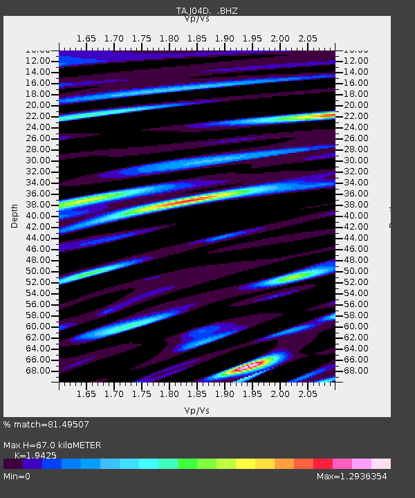
| Estimated Moho Depth: |
67.0 km |
| Estimated Crust Vp/Vs: |
1.94 |
| Assumed Crust Vp: |
6.522 km/s |
| Estimated Crust Vs: |
3.357 km/s |
| Estimated Crust Poisson's Ratio: |
0.32 |
|
| Radial Match: |
81.49507 % |
| Radial Bump: |
400 |
| Transverse Match: |
84.004616 % |
| Transverse Bump: |
400 |
| SOD ConfigId: |
424168 |
| Insert Time: |
2012-02-24 06:23:09.782 +0000 |
| GWidth: |
2.5 |
| Max Bumps: |
400 |
| Tol: |
0.001 |
|

Signal To Noise
| Channel | StoN | STA | LTA |
| TA:J04D: :BHZ:20111108T03:10:53.37499Z | 19.609184 | 6.850916E-6 | 3.493728E-7 |
| TA:J04D: :BHN:20111108T03:10:53.37499Z | 2.3752816 | 1.2838232E-6 | 5.404931E-7 |
| TA:J04D: :BHE:20111108T03:10:53.37499Z | 4.703754 | 2.7628002E-6 | 5.873607E-7 |
| Arrivals |
| Ps | 9.9 SECOND |
| PpPs | 30 SECOND |
| PsPs/PpSs | 39 SECOND |


