You are here: Home > Network List > TA - USArray Transportable Network (new EarthScope stations) Stations List
> Station G05D Wamic, OR, USA > Earthquake Result Viewer
G05D Wamic, OR, USA - Earthquake Result Viewer
*The percent match for this event was below the threshold and hence no stack was calculated.
| Earthquake location: |
Northeast Of Taiwan |
| Earthquake latitude/longitude: |
27.3/125.6 |
| Earthquake time(UTC): |
2011/11/08 (312) 02:59:08 GMT |
| Earthquake Depth: |
225 km |
| Earthquake Magnitude: |
6.5 MB, 6.9 MW, 6.9 MW |
| Earthquake Catalog/Contributor: |
WHDF/NEIC |
|
| Network: |
TA USArray Transportable Network (new EarthScope stations) |
| Station: |
G05D Wamic, OR, USA |
| Lat/Lon: |
45.24 N/121.32 W |
| Elevation: |
592 m |
|
| Distance: |
85.6 deg |
| Az: |
40.69 deg |
| Baz: |
304.814 deg |
| Ray Param: |
$rayparam |
*The percent match for this event was below the threshold and hence was not used in the summary stack. |
|
| Radial Match: |
84.78744 % |
| Radial Bump: |
400 |
| Transverse Match: |
66.553635 % |
| Transverse Bump: |
400 |
| SOD ConfigId: |
424168 |
| Insert Time: |
2012-02-24 06:23:31.956 +0000 |
| GWidth: |
2.5 |
| Max Bumps: |
400 |
| Tol: |
0.001 |
|
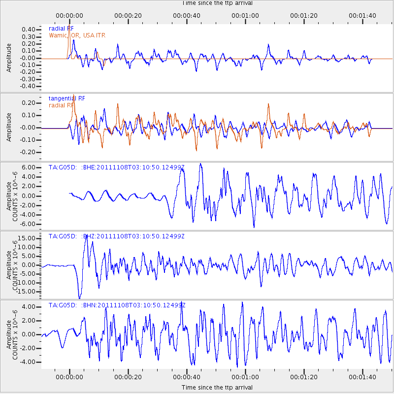
Signal To Noise
| Channel | StoN | STA | LTA |
| TA:G05D: :BHZ:20111108T03:10:50.12499Z | 22.791739 | 8.411809E-6 | 3.6907275E-7 |
| TA:G05D: :BHN:20111108T03:10:50.12499Z | 1.3655753 | 9.873595E-7 | 7.230356E-7 |
| TA:G05D: :BHE:20111108T03:10:50.12499Z | 2.9067838 | 1.7067895E-6 | 5.8717455E-7 |
| Arrivals |
| Ps | |
| PpPs | |
| PsPs/PpSs | |


