You are here: Home > Network List > TA - USArray Transportable Network (new EarthScope stations) Stations List
> Station B31A Greenbush Farm, Park River, ND, USA > Earthquake Result Viewer
B31A Greenbush Farm, Park River, ND, USA - Earthquake Result Viewer
| Earthquake location: |
Northeast Of Taiwan |
| Earthquake latitude/longitude: |
27.3/125.6 |
| Earthquake time(UTC): |
2011/11/08 (312) 02:59:08 GMT |
| Earthquake Depth: |
225 km |
| Earthquake Magnitude: |
6.5 MB, 6.9 MW, 6.9 MW |
| Earthquake Catalog/Contributor: |
WHDF/NEIC |
|
| Network: |
TA USArray Transportable Network (new EarthScope stations) |
| Station: |
B31A Greenbush Farm, Park River, ND, USA |
| Lat/Lon: |
48.42 N/97.65 W |
| Elevation: |
279 m |
|
| Distance: |
95.2 deg |
| Az: |
27.289 deg |
| Baz: |
322.24 deg |
| Ray Param: |
0.040658884 |
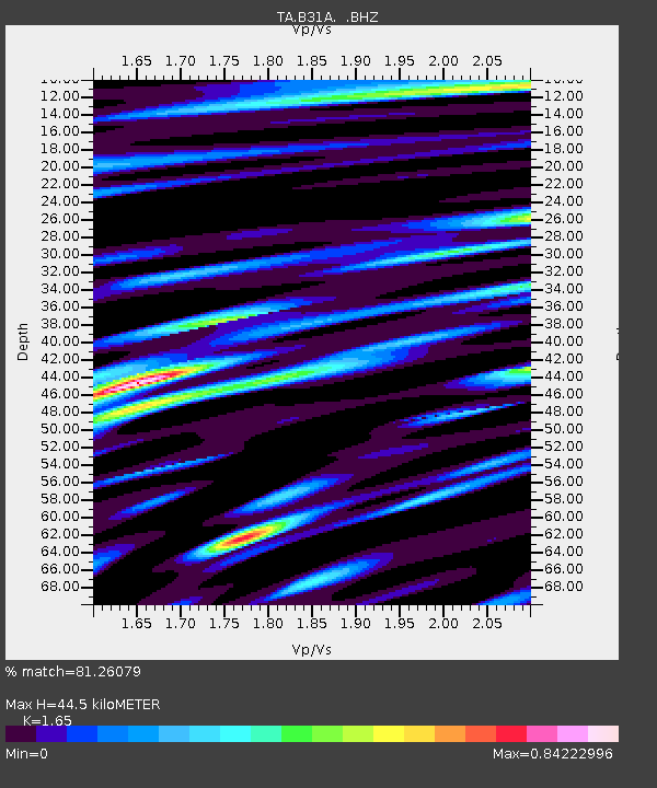
| Estimated Moho Depth: |
44.5 km |
| Estimated Crust Vp/Vs: |
1.65 |
| Assumed Crust Vp: |
6.498 km/s |
| Estimated Crust Vs: |
3.938 km/s |
| Estimated Crust Poisson's Ratio: |
0.21 |
|
| Radial Match: |
81.26079 % |
| Radial Bump: |
400 |
| Transverse Match: |
68.550835 % |
| Transverse Bump: |
400 |
| SOD ConfigId: |
424168 |
| Insert Time: |
2012-02-24 06:25:00.166 +0000 |
| GWidth: |
2.5 |
| Max Bumps: |
400 |
| Tol: |
0.001 |
|

Signal To Noise
| Channel | StoN | STA | LTA |
| TA:B31A: :BHZ:20111108T03:11:34.900015Z | 9.301798 | 2.5623442E-6 | 2.754676E-7 |
| TA:B31A: :BHN:20111108T03:11:34.900015Z | 3.880568 | 7.40593E-7 | 1.9084655E-7 |
| TA:B31A: :BHE:20111108T03:11:34.900015Z | 2.2736301 | 5.3280024E-7 | 2.3433903E-7 |
| Arrivals |
| Ps | 4.5 SECOND |
| PpPs | 18 SECOND |
| PsPs/PpSs | 22 SECOND |


