You are here: Home > Network List > TA - USArray Transportable Network (new EarthScope stations) Stations List
> Station A31A Linda, St. Vincent, MN, USA > Earthquake Result Viewer
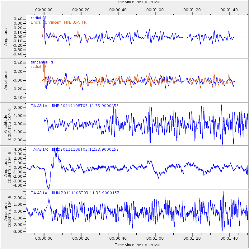
A31A Linda, St. Vincent, MN, USA - Earthquake Result Viewer
*The percent match for this event was below the threshold and hence no stack was calculated.
| Earthquake location: |
Northeast Of Taiwan |
| Earthquake latitude/longitude: |
27.3/125.6 |
| Earthquake time(UTC): |
2011/11/08 (312) 02:59:08 GMT |
| Earthquake Depth: |
225 km |
| Earthquake Magnitude: |
6.5 MB, 6.9 MW, 6.9 MW |
| Earthquake Catalog/Contributor: |
WHDF/NEIC |
|
| Network: |
TA USArray Transportable Network (new EarthScope stations) |
| Station: |
A31A Linda, St. Vincent, MN, USA |
| Lat/Lon: |
48.93 N/97.19 W |
| Elevation: |
244 m |
|
| Distance: |
95.0 deg |
| Az: |
26.735 deg |
| Baz: |
322.634 deg |
| Ray Param: |
$rayparam |
*The percent match for this event was below the threshold and hence was not used in the summary stack. |
|
| Radial Match: |
61.9921 % |
| Radial Bump: |
400 |
| Transverse Match: |
52.362514 % |
| Transverse Bump: |
400 |
| SOD ConfigId: |
424168 |
| Insert Time: |
2012-02-24 06:26:16.368 +0000 |
| GWidth: |
2.5 |
| Max Bumps: |
400 |
| Tol: |
0.001 |
|
Signal To Noise
| Channel | StoN | STA | LTA |
| TA:A31A: :BHZ:20111108T03:11:33.900015Z | 6.278831 | 2.5034662E-6 | 3.9871534E-7 |
| TA:A31A: :BHN:20111108T03:11:33.900015Z | 2.7079957 | 9.3184445E-7 | 3.4410857E-7 |
| TA:A31A: :BHE:20111108T03:11:33.900015Z | 1.7925645 | 6.4220154E-7 | 3.5825855E-7 |
| Arrivals |
| Ps | |
| PpPs | |
| PsPs/PpSs | |


