You are here: Home > Network List > TA - USArray Transportable Network (new EarthScope stations) Stations List
> Station F31A Hecla, SD, USA > Earthquake Result Viewer
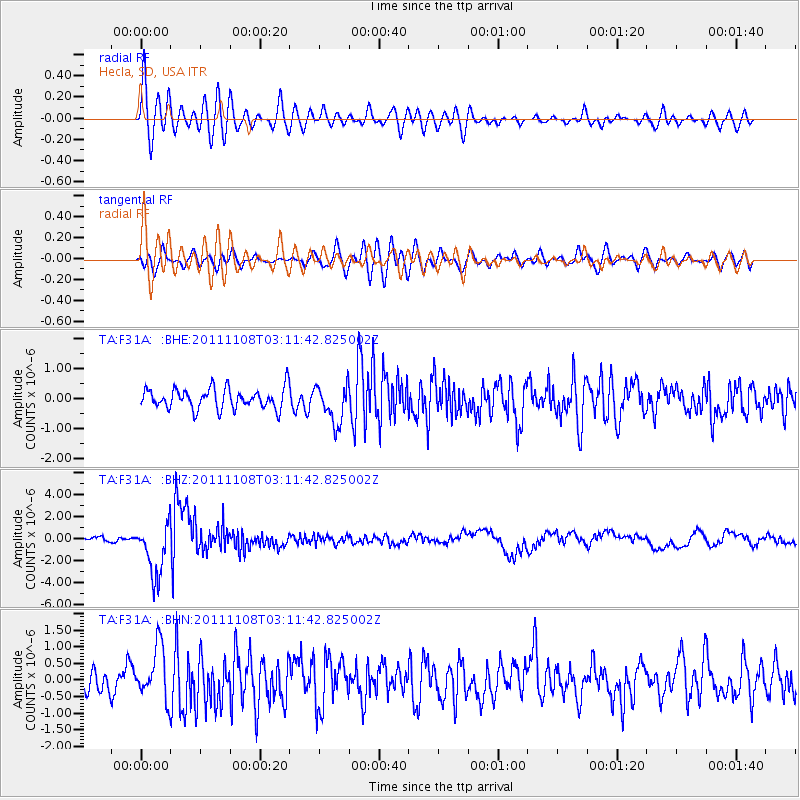
F31A Hecla, SD, USA - Earthquake Result Viewer
*The percent match for this event was below the threshold and hence no stack was calculated.
| Earthquake location: |
Northeast Of Taiwan |
| Earthquake latitude/longitude: |
27.3/125.6 |
| Earthquake time(UTC): |
2011/11/08 (312) 02:59:08 GMT |
| Earthquake Depth: |
225 km |
| Earthquake Magnitude: |
6.5 MB, 6.9 MW, 6.9 MW |
| Earthquake Catalog/Contributor: |
WHDF/NEIC |
|
| Network: |
TA USArray Transportable Network (new EarthScope stations) |
| Station: |
F31A Hecla, SD, USA |
| Lat/Lon: |
45.86 N/98.25 W |
| Elevation: |
412 m |
|
| Distance: |
97.0 deg |
| Az: |
29.206 deg |
| Baz: |
321.595 deg |
| Ray Param: |
$rayparam |
*The percent match for this event was below the threshold and hence was not used in the summary stack. |
|
| Radial Match: |
76.92556 % |
| Radial Bump: |
400 |
| Transverse Match: |
63.061954 % |
| Transverse Bump: |
400 |
| SOD ConfigId: |
424168 |
| Insert Time: |
2012-02-24 06:26:45.945 +0000 |
| GWidth: |
2.5 |
| Max Bumps: |
400 |
| Tol: |
0.001 |
|
Signal To Noise
| Channel | StoN | STA | LTA |
| TA:F31A: :BHZ:20111108T03:11:42.825002Z | 16.607975 | 2.4516496E-6 | 1.4761882E-7 |
| TA:F31A: :BHN:20111108T03:11:42.825002Z | 2.5899658 | 7.977342E-7 | 3.0800953E-7 |
| TA:F31A: :BHE:20111108T03:11:42.825002Z | 1.8838973 | 6.423547E-7 | 3.4097116E-7 |
| Arrivals |
| Ps | |
| PpPs | |
| PsPs/PpSs | |


