You are here: Home > Network List > UW - Pacific Northwest Regional Seismic Network Stations List
> Station HOOD Mt Hood Meadows, OR CREST BB SMO > Earthquake Result Viewer
HOOD Mt Hood Meadows, OR CREST BB SMO - Earthquake Result Viewer
| Earthquake location: |
Northeast Of Taiwan |
| Earthquake latitude/longitude: |
27.3/125.6 |
| Earthquake time(UTC): |
2011/11/08 (312) 02:59:08 GMT |
| Earthquake Depth: |
225 km |
| Earthquake Magnitude: |
6.5 MB, 6.9 MW, 6.9 MW |
| Earthquake Catalog/Contributor: |
WHDF/NEIC |
|
| Network: |
UW Pacific Northwest Regional Seismic Network |
| Station: |
HOOD Mt Hood Meadows, OR CREST BB SMO |
| Lat/Lon: |
45.32 N/121.65 W |
| Elevation: |
1520 m |
|
| Distance: |
85.3 deg |
| Az: |
40.76 deg |
| Baz: |
304.582 deg |
| Ray Param: |
0.04429009 |
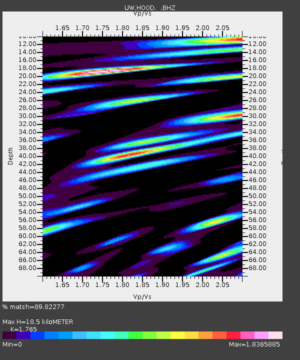
| Estimated Moho Depth: |
18.5 km |
| Estimated Crust Vp/Vs: |
1.76 |
| Assumed Crust Vp: |
6.597 km/s |
| Estimated Crust Vs: |
3.738 km/s |
| Estimated Crust Poisson's Ratio: |
0.26 |
|
| Radial Match: |
89.82277 % |
| Radial Bump: |
400 |
| Transverse Match: |
84.62294 % |
| Transverse Bump: |
400 |
| SOD ConfigId: |
424168 |
| Insert Time: |
2012-02-24 06:29:26.404 +0000 |
| GWidth: |
2.5 |
| Max Bumps: |
400 |
| Tol: |
0.001 |
|

Signal To Noise
| Channel | StoN | STA | LTA |
| UW:HOOD: :BHZ:20111108T03:10:48.960012Z | 39.002117 | 6.162441E-6 | 1.5800273E-7 |
| UW:HOOD: :BHN:20111108T03:10:48.960012Z | 4.1162195 | 1.4850315E-6 | 3.6077557E-7 |
| UW:HOOD: :BHE:20111108T03:10:48.960012Z | 5.2117352 | 1.8464332E-6 | 3.5428374E-7 |
| Arrivals |
| Ps | 2.2 SECOND |
| PpPs | 7.6 SECOND |
| PsPs/PpSs | 9.8 SECOND |


