You are here: Home > Network List > UW - Pacific Northwest Regional Seismic Network Stations List
> Station OMAK Colville Reservation, Omak, WA, USA > Earthquake Result Viewer
OMAK Colville Reservation, Omak, WA, USA - Earthquake Result Viewer
| Earthquake location: |
Northeast Of Taiwan |
| Earthquake latitude/longitude: |
27.3/125.6 |
| Earthquake time(UTC): |
2011/11/08 (312) 02:59:08 GMT |
| Earthquake Depth: |
225 km |
| Earthquake Magnitude: |
6.5 MB, 6.9 MW, 6.9 MW |
| Earthquake Catalog/Contributor: |
WHDF/NEIC |
|
| Network: |
UW Pacific Northwest Regional Seismic Network |
| Station: |
OMAK Colville Reservation, Omak, WA, USA |
| Lat/Lon: |
48.36 N/119.33 W |
| Elevation: |
696 m |
|
| Distance: |
84.9 deg |
| Az: |
37.348 deg |
| Baz: |
305.979 deg |
| Ray Param: |
0.04460914 |
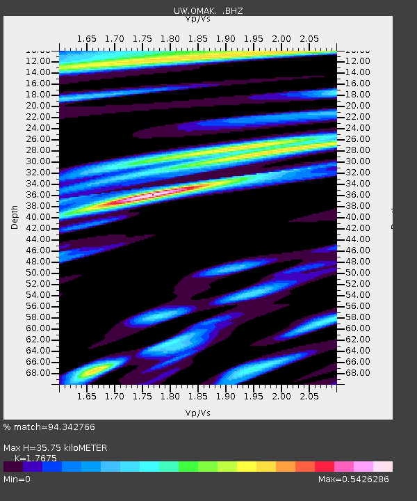
| Estimated Moho Depth: |
35.75 km |
| Estimated Crust Vp/Vs: |
1.77 |
| Assumed Crust Vp: |
6.419 km/s |
| Estimated Crust Vs: |
3.632 km/s |
| Estimated Crust Poisson's Ratio: |
0.26 |
|
| Radial Match: |
94.342766 % |
| Radial Bump: |
400 |
| Transverse Match: |
84.44274 % |
| Transverse Bump: |
400 |
| SOD ConfigId: |
424168 |
| Insert Time: |
2012-02-24 06:29:57.822 +0000 |
| GWidth: |
2.5 |
| Max Bumps: |
400 |
| Tol: |
0.001 |
|
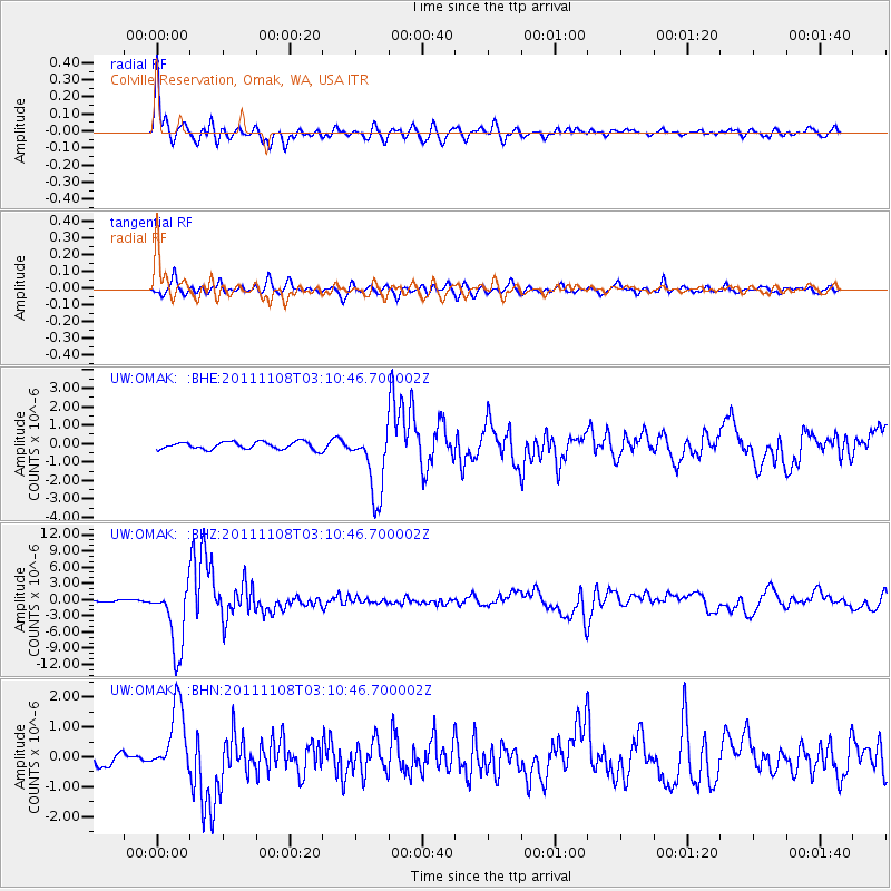
Signal To Noise
| Channel | StoN | STA | LTA |
| UW:OMAK: :BHZ:20111108T03:10:46.700002Z | 40.463535 | 6.207294E-6 | 1.5340464E-7 |
| UW:OMAK: :BHN:20111108T03:10:46.700002Z | 8.093828 | 1.1580898E-6 | 1.4308307E-7 |
| UW:OMAK: :BHE:20111108T03:10:46.700002Z | 9.209197 | 1.8456398E-6 | 2.0041266E-7 |
| Arrivals |
| Ps | 4.4 SECOND |
| PpPs | 15 SECOND |
| PsPs/PpSs | 19 SECOND |


