You are here: Home > Network List > TA - USArray Transportable Network (new EarthScope stations) Stations List
> Station E62A Clayton Lake, ME, USA > Earthquake Result Viewer
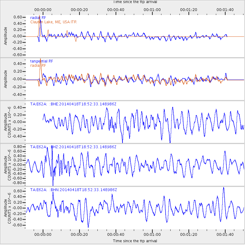
E62A Clayton Lake, ME, USA - Earthquake Result Viewer
*The percent match for this event was below the threshold and hence no stack was calculated.
| Earthquake location: |
Northern Alaska |
| Earthquake latitude/longitude: |
67.7/-162.5 |
| Earthquake time(UTC): |
2014/04/18 (108) 18:44:17 GMT |
| Earthquake Depth: |
1.0 km |
| Earthquake Magnitude: |
5.5 MB, 5.4 MI |
| Earthquake Catalog/Contributor: |
NEIC PDE/NEIC COMCAT |
|
| Network: |
TA USArray Transportable Network (new EarthScope stations) |
| Station: |
E62A Clayton Lake, ME, USA |
| Lat/Lon: |
46.62 N/69.52 W |
| Elevation: |
356 m |
|
| Distance: |
49.0 deg |
| Az: |
65.769 deg |
| Baz: |
329.631 deg |
| Ray Param: |
$rayparam |
*The percent match for this event was below the threshold and hence was not used in the summary stack. |
|
| Radial Match: |
65.31837 % |
| Radial Bump: |
400 |
| Transverse Match: |
47.53234 % |
| Transverse Bump: |
398 |
| SOD ConfigId: |
3390531 |
| Insert Time: |
2019-04-11 11:29:28.407 +0000 |
| GWidth: |
2.5 |
| Max Bumps: |
400 |
| Tol: |
0.001 |
|
Signal To Noise
| Channel | StoN | STA | LTA |
| TA:E62A: :BHZ:20140418T18:52:33.148986Z | 2.086018 | 3.8377354E-7 | 1.8397421E-7 |
| TA:E62A: :BHN:20140418T18:52:33.148986Z | 1.282116 | 2.0551744E-7 | 1.602955E-7 |
| TA:E62A: :BHE:20140418T18:52:33.148986Z | 1.4403536 | 1.9730491E-7 | 1.3698366E-7 |
| Arrivals |
| Ps | |
| PpPs | |
| PsPs/PpSs | |


