You are here: Home > Network List > TA - USArray Transportable Network (new EarthScope stations) Stations List
> Station M42A Sheffield, IL, USA > Earthquake Result Viewer
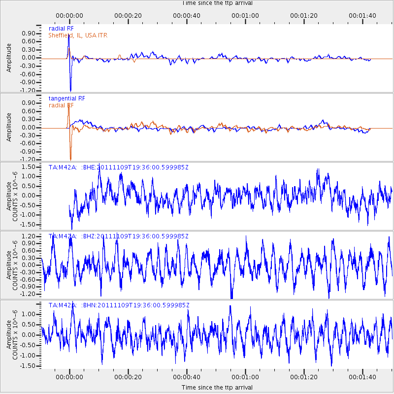
M42A Sheffield, IL, USA - Earthquake Result Viewer
*The percent match for this event was below the threshold and hence no stack was calculated.
| Earthquake location: |
Turkey |
| Earthquake latitude/longitude: |
38.4/43.2 |
| Earthquake time(UTC): |
2011/11/09 (313) 19:23:33 GMT |
| Earthquake Depth: |
5.0 km |
| Earthquake Magnitude: |
5.6 MB, 5.6 MS, 5.6 MW, 5.6 MW |
| Earthquake Catalog/Contributor: |
WHDF/NEIC |
|
| Network: |
TA USArray Transportable Network (new EarthScope stations) |
| Station: |
M42A Sheffield, IL, USA |
| Lat/Lon: |
41.45 N/89.76 W |
| Elevation: |
212 m |
|
| Distance: |
89.7 deg |
| Az: |
326.642 deg |
| Baz: |
35.067 deg |
| Ray Param: |
$rayparam |
*The percent match for this event was below the threshold and hence was not used in the summary stack. |
|
| Radial Match: |
64.31177 % |
| Radial Bump: |
400 |
| Transverse Match: |
39.217197 % |
| Transverse Bump: |
400 |
| SOD ConfigId: |
424168 |
| Insert Time: |
2012-02-24 06:48:23.421 +0000 |
| GWidth: |
2.5 |
| Max Bumps: |
400 |
| Tol: |
0.001 |
|
Signal To Noise
| Channel | StoN | STA | LTA |
| TA:M42A: :BHZ:20111109T19:36:00.599985Z | 0.9843782 | 5.528661E-7 | 5.616399E-7 |
| TA:M42A: :BHN:20111109T19:36:00.599985Z | 1.1478449 | 6.8781804E-7 | 5.992256E-7 |
| TA:M42A: :BHE:20111109T19:36:00.599985Z | 0.6803389 | 4.066412E-7 | 5.9770383E-7 |
| Arrivals |
| Ps | |
| PpPs | |
| PsPs/PpSs | |


