You are here: Home > Network List > G - GEOSCOPE Stations List
> Station RER Riviere de l'Est, La Reunion (Indian Ocean) > Earthquake Result Viewer
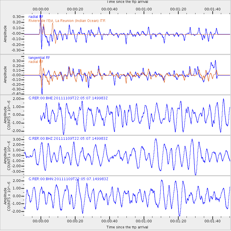
RER Riviere de l'Est, La Reunion (Indian Ocean) - Earthquake Result Viewer
*The percent match for this event was below the threshold and hence no stack was calculated.
| Earthquake location: |
E. Caroline Islands, Micronesia |
| Earthquake latitude/longitude: |
10.5/146.1 |
| Earthquake time(UTC): |
2011/11/09 (313) 21:52:20 GMT |
| Earthquake Depth: |
10 km |
| Earthquake Magnitude: |
5.6 MB, 5.4 MS, 5.7 MW, 5.5 MW |
| Earthquake Catalog/Contributor: |
WHDF/NEIC |
|
| Network: |
G GEOSCOPE |
| Station: |
RER Riviere de l'Est, La Reunion (Indian Ocean) |
| Lat/Lon: |
21.16 S/55.75 E |
| Elevation: |
834 m |
|
| Distance: |
94.1 deg |
| Az: |
249.346 deg |
| Baz: |
80.332 deg |
| Ray Param: |
$rayparam |
*The percent match for this event was below the threshold and hence was not used in the summary stack. |
|
| Radial Match: |
39.82606 % |
| Radial Bump: |
400 |
| Transverse Match: |
58.383133 % |
| Transverse Bump: |
400 |
| SOD ConfigId: |
424168 |
| Insert Time: |
2012-02-24 06:58:51.106 +0000 |
| GWidth: |
2.5 |
| Max Bumps: |
400 |
| Tol: |
0.001 |
|
Signal To Noise
| Channel | StoN | STA | LTA |
| G:RER:00:BHZ:20111109T22:05:07.149983Z | 2.396521 | 1.8101925E-6 | 7.5534183E-7 |
| G:RER:00:BHN:20111109T22:05:07.149983Z | 1.0842139 | 7.274263E-7 | 6.7092515E-7 |
| G:RER:00:BHE:20111109T22:05:07.149983Z | 0.8530104 | 7.1804874E-7 | 8.417819E-7 |
| Arrivals |
| Ps | |
| PpPs | |
| PsPs/PpSs | |


