You are here: Home > Network List > TA - USArray Transportable Network (new EarthScope stations) Stations List
> Station Y43A Makayla and Karen, Gunnison, MS, USA > Earthquake Result Viewer
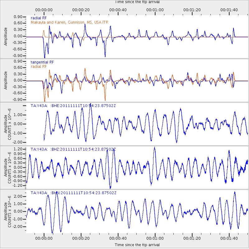
Y43A Makayla and Karen, Gunnison, MS, USA - Earthquake Result Viewer
*The percent match for this event was below the threshold and hence no stack was calculated.
| Earthquake location: |
Southern East Pacific Rise |
| Earthquake latitude/longitude: |
-56.0/-124.4 |
| Earthquake time(UTC): |
2011/11/11 (315) 10:41:37 GMT |
| Earthquake Depth: |
10 km |
| Earthquake Magnitude: |
5.6 MS, 5.1 MB, 6.0 MW, 6.1 MW |
| Earthquake Catalog/Contributor: |
WHDF/NEIC |
|
| Network: |
TA USArray Transportable Network (new EarthScope stations) |
| Station: |
Y43A Makayla and Karen, Gunnison, MS, USA |
| Lat/Lon: |
33.91 N/90.93 W |
| Elevation: |
46 m |
|
| Distance: |
94.0 deg |
| Az: |
27.403 deg |
| Baz: |
198.123 deg |
| Ray Param: |
$rayparam |
*The percent match for this event was below the threshold and hence was not used in the summary stack. |
|
| Radial Match: |
61.7727 % |
| Radial Bump: |
400 |
| Transverse Match: |
34.584206 % |
| Transverse Bump: |
342 |
| SOD ConfigId: |
424168 |
| Insert Time: |
2012-02-24 07:13:08.468 +0000 |
| GWidth: |
2.5 |
| Max Bumps: |
400 |
| Tol: |
0.001 |
|
Signal To Noise
| Channel | StoN | STA | LTA |
| TA:Y43A: :BHZ:20111111T10:54:23.87502Z | 0.45595658 | 2.348362E-7 | 5.150407E-7 |
| TA:Y43A: :BHN:20111111T10:54:23.87502Z | 3.455554 | 1.6601737E-6 | 4.8043637E-7 |
| TA:Y43A: :BHE:20111111T10:54:23.87502Z | 0.51388603 | 4.711126E-7 | 9.1676475E-7 |
| Arrivals |
| Ps | |
| PpPs | |
| PsPs/PpSs | |


