You are here: Home > Network List > TA - USArray Transportable Network (new EarthScope stations) Stations List
> Station X45A UM Field Station, Abbeville, MS, USA > Earthquake Result Viewer
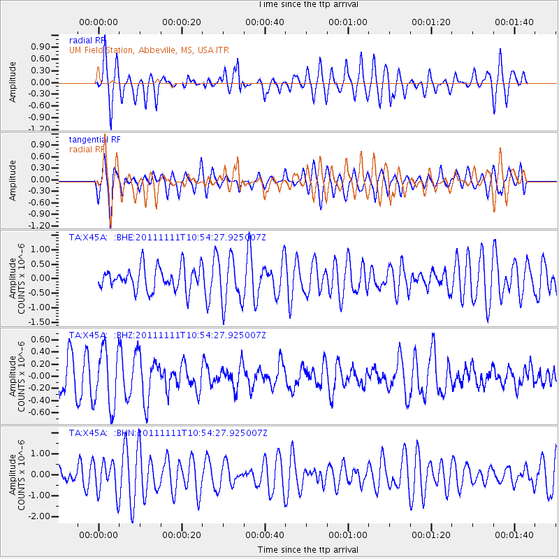
X45A UM Field Station, Abbeville, MS, USA - Earthquake Result Viewer
*The percent match for this event was below the threshold and hence no stack was calculated.
| Earthquake location: |
Southern East Pacific Rise |
| Earthquake latitude/longitude: |
-56.0/-124.4 |
| Earthquake time(UTC): |
2011/11/11 (315) 10:41:37 GMT |
| Earthquake Depth: |
10 km |
| Earthquake Magnitude: |
5.6 MS, 5.1 MB, 6.0 MW, 6.1 MW |
| Earthquake Catalog/Contributor: |
WHDF/NEIC |
|
| Network: |
TA USArray Transportable Network (new EarthScope stations) |
| Station: |
X45A UM Field Station, Abbeville, MS, USA |
| Lat/Lon: |
34.42 N/89.39 W |
| Elevation: |
142 m |
|
| Distance: |
94.9 deg |
| Az: |
28.451 deg |
| Baz: |
198.9 deg |
| Ray Param: |
$rayparam |
*The percent match for this event was below the threshold and hence was not used in the summary stack. |
|
| Radial Match: |
56.52444 % |
| Radial Bump: |
400 |
| Transverse Match: |
70.7724 % |
| Transverse Bump: |
400 |
| SOD ConfigId: |
424168 |
| Insert Time: |
2012-02-24 07:13:23.140 +0000 |
| GWidth: |
2.5 |
| Max Bumps: |
400 |
| Tol: |
0.001 |
|
Signal To Noise
| Channel | StoN | STA | LTA |
| TA:X45A: :BHZ:20111111T10:54:27.925007Z | 2.2790937 | 4.794999E-7 | 2.103906E-7 |
| TA:X45A: :BHN:20111111T10:54:27.925007Z | 1.4726356 | 7.8045343E-7 | 5.299705E-7 |
| TA:X45A: :BHE:20111111T10:54:27.925007Z | 1.9959255 | 7.9416367E-7 | 3.9789245E-7 |
| Arrivals |
| Ps | |
| PpPs | |
| PsPs/PpSs | |


