You are here: Home > Network List > G - GEOSCOPE Stations List
> Station DZM Dzumac, New Caledonia > Earthquake Result Viewer
DZM Dzumac, New Caledonia - Earthquake Result Viewer
| Earthquake location: |
Southern Molucca Sea |
| Earthquake latitude/longitude: |
-0.9/126.9 |
| Earthquake time(UTC): |
2011/11/14 (318) 04:05:11 GMT |
| Earthquake Depth: |
17 km |
| Earthquake Magnitude: |
6.2 MB, 6.2 MS, 6.3 MW, 6.3 MW |
| Earthquake Catalog/Contributor: |
WHDF/NEIC |
|
| Network: |
G GEOSCOPE |
| Station: |
DZM Dzumac, New Caledonia |
| Lat/Lon: |
22.07 S/166.44 E |
| Elevation: |
878 m |
|
| Distance: |
43.8 deg |
| Az: |
121.497 deg |
| Baz: |
293.205 deg |
| Ray Param: |
0.072281085 |
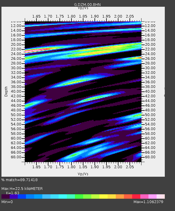
| Estimated Moho Depth: |
22.5 km |
| Estimated Crust Vp/Vs: |
1.63 |
| Assumed Crust Vp: |
5.14 km/s |
| Estimated Crust Vs: |
3.153 km/s |
| Estimated Crust Poisson's Ratio: |
0.20 |
|
| Radial Match: |
89.71418 % |
| Radial Bump: |
400 |
| Transverse Match: |
78.3517 % |
| Transverse Bump: |
400 |
| SOD ConfigId: |
432046 |
| Insert Time: |
2012-02-28 05:42:48.929 +0000 |
| GWidth: |
2.5 |
| Max Bumps: |
400 |
| Tol: |
0.001 |
|
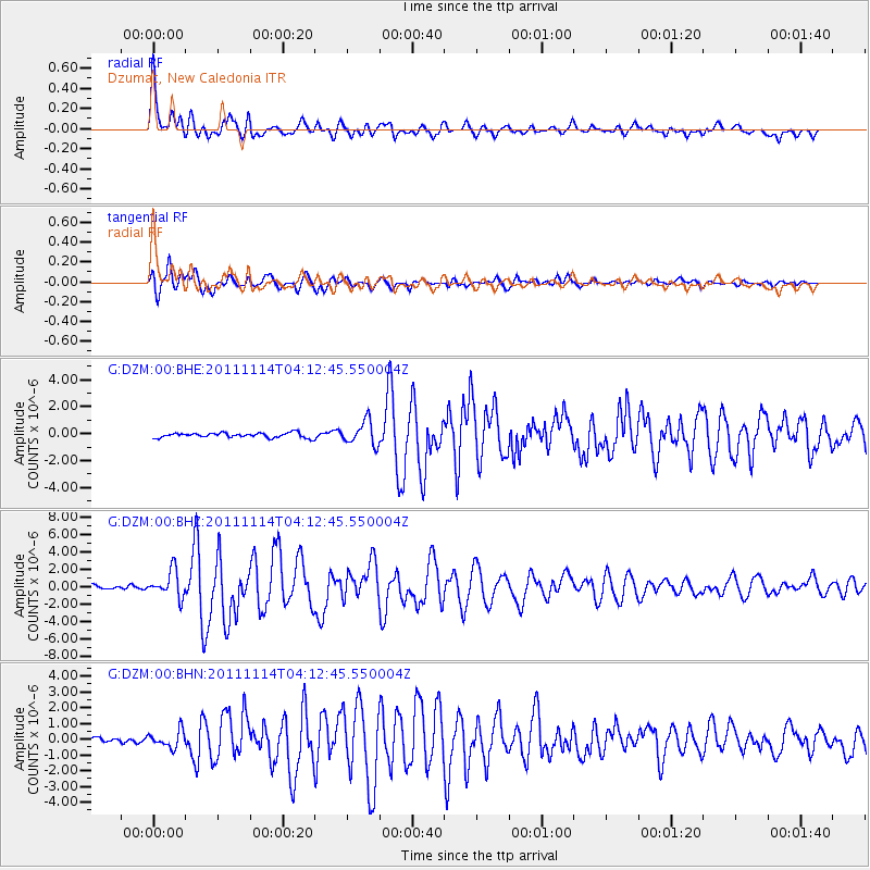
Signal To Noise
| Channel | StoN | STA | LTA |
| G:DZM:00:BHZ:20111114T04:12:45.550004Z | 7.033336 | 1.5241279E-6 | 2.1670057E-7 |
| G:DZM:00:BHN:20111114T04:12:45.550004Z | 2.300735 | 5.3174307E-7 | 2.3111879E-7 |
| G:DZM:00:BHE:20111114T04:12:45.550004Z | 5.066768 | 8.8751534E-7 | 1.7516399E-7 |
| Arrivals |
| Ps | 2.9 SECOND |
| PpPs | 11 SECOND |
| PsPs/PpSs | 14 SECOND |


