You are here: Home > Network List > G - GEOSCOPE Stations List
> Station HYB Hyderabad, India > Earthquake Result Viewer
HYB Hyderabad, India - Earthquake Result Viewer

| Earthquake location: |
Near West Coast Of Honshu, Japan |
| Earthquake latitude/longitude: |
37.6/137.3 |
| Earthquake time(UTC): |
1993/02/07 (038) 13:27:43 GMT |
| Earthquake Depth: |
24 km |
| Earthquake Magnitude: |
6.3 MB, 6.1 MS |
| Earthquake Catalog/Contributor: |
WHDF/NEIC |
|
| Network: |
G GEOSCOPE |
| Station: |
HYB Hyderabad, India |
| Lat/Lon: |
17.42 N/78.55 E |
| Elevation: |
510 m |
|
| Distance: |
54.9 deg |
| Az: |
265.437 deg |
| Baz: |
56.014 deg |
| Ray Param: |
0.065096565 |
| Estimated Moho Depth: |
35.0 km |
| Estimated Crust Vp/Vs: |
1.63 |
| Assumed Crust Vp: |
6.459 km/s |
| Estimated Crust Vs: |
3.963 km/s |
| Estimated Crust Poisson's Ratio: |
0.20 |
|
| Radial Match: |
96.73701 % |
| Radial Bump: |
400 |
| Transverse Match: |
86.93596 % |
| Transverse Bump: |
400 |
| SOD ConfigId: |
16938 |
| Insert Time: |
2010-02-26 22:49:46.642 +0000 |
| GWidth: |
2.5 |
| Max Bumps: |
400 |
| Tol: |
0.001 |
|
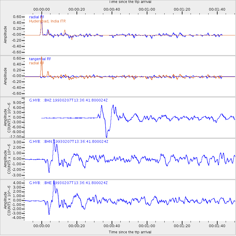
Signal To Noise
| Channel | StoN | STA | LTA |
| G:HYB: :BHN:19930207T13:36:41.800024Z | 24.4916 | 8.3802814E-7 | 3.4216963E-8 |
| G:HYB: :BHE:19930207T13:36:41.800024Z | 33.615265 | 1.1048505E-6 | 3.2867522E-8 |
| G:HYB: :BHZ:19930207T13:36:41.800024Z | 77.26001 | 2.744881E-6 | 3.5527837E-8 |
| Arrivals |
| Ps | 3.6 SECOND |
| PpPs | 13 SECOND |
| PsPs/PpSs | 17 SECOND |


