You are here: Home > Network List > AU - Australian Seismological Centre Stations List
> Station RABL Rabaul, Papau New Guinea > Earthquake Result Viewer
RABL Rabaul, Papau New Guinea - Earthquake Result Viewer
| Earthquake location: |
Minahassa Peninsula, Sulawesi |
| Earthquake latitude/longitude: |
-0.1/121.9 |
| Earthquake time(UTC): |
2011/11/15 (319) 10:43:51 GMT |
| Earthquake Depth: |
276 km |
| Earthquake Magnitude: |
5.7 MB, 5.7 MW, 5.8 MW |
| Earthquake Catalog/Contributor: |
WHDF/NEIC |
|
| Network: |
AU Australian Seismological Centre |
| Station: |
RABL Rabaul, Papau New Guinea |
| Lat/Lon: |
4.19 S/152.16 E |
| Elevation: |
277 m |
|
| Distance: |
30.5 deg |
| Az: |
98.063 deg |
| Baz: |
276.912 deg |
| Ray Param: |
0.07858997 |
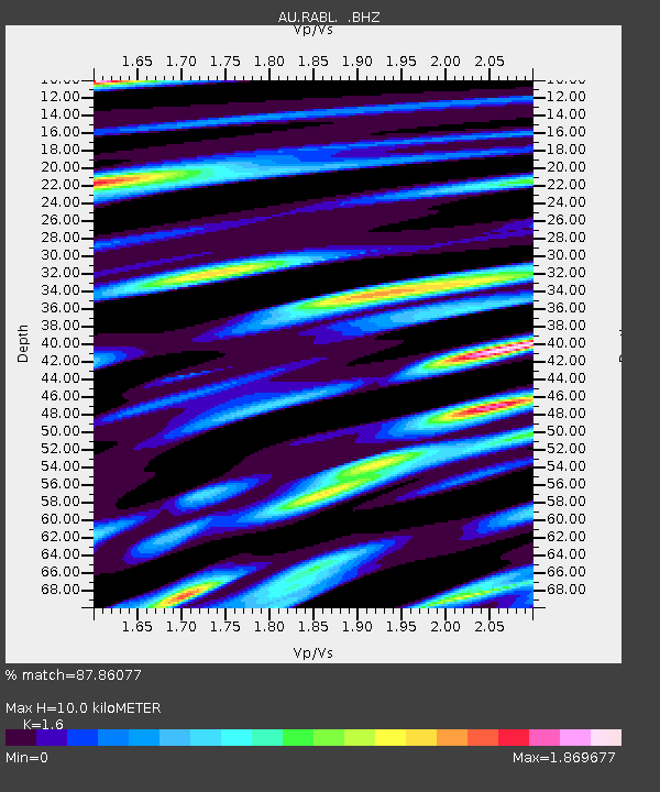
| Estimated Moho Depth: |
10.0 km |
| Estimated Crust Vp/Vs: |
1.60 |
| Assumed Crust Vp: |
6.183 km/s |
| Estimated Crust Vs: |
3.864 km/s |
| Estimated Crust Poisson's Ratio: |
0.18 |
|
| Radial Match: |
87.86077 % |
| Radial Bump: |
400 |
| Transverse Match: |
80.9694 % |
| Transverse Bump: |
400 |
| SOD ConfigId: |
432046 |
| Insert Time: |
2012-02-28 05:54:54.923 +0000 |
| GWidth: |
2.5 |
| Max Bumps: |
400 |
| Tol: |
0.001 |
|

Signal To Noise
| Channel | StoN | STA | LTA |
| AU:RABL: :BHZ:20111115T10:49:09.219995Z | 52.140224 | 5.384292E-6 | 1.032656E-7 |
| AU:RABL: :BHN:20111115T10:49:09.219995Z | 10.628746 | 2.524373E-6 | 2.3750432E-7 |
| AU:RABL: :BHE:20111115T10:49:09.219995Z | 16.502754 | 3.986668E-6 | 2.4157595E-7 |
| Arrivals |
| Ps | 1.1 SECOND |
| PpPs | 3.9 SECOND |
| PsPs/PpSs | 4.9 SECOND |


