You are here: Home > Network List > G - GEOSCOPE Stations List
> Station INU Inuyama, Japan > Earthquake Result Viewer
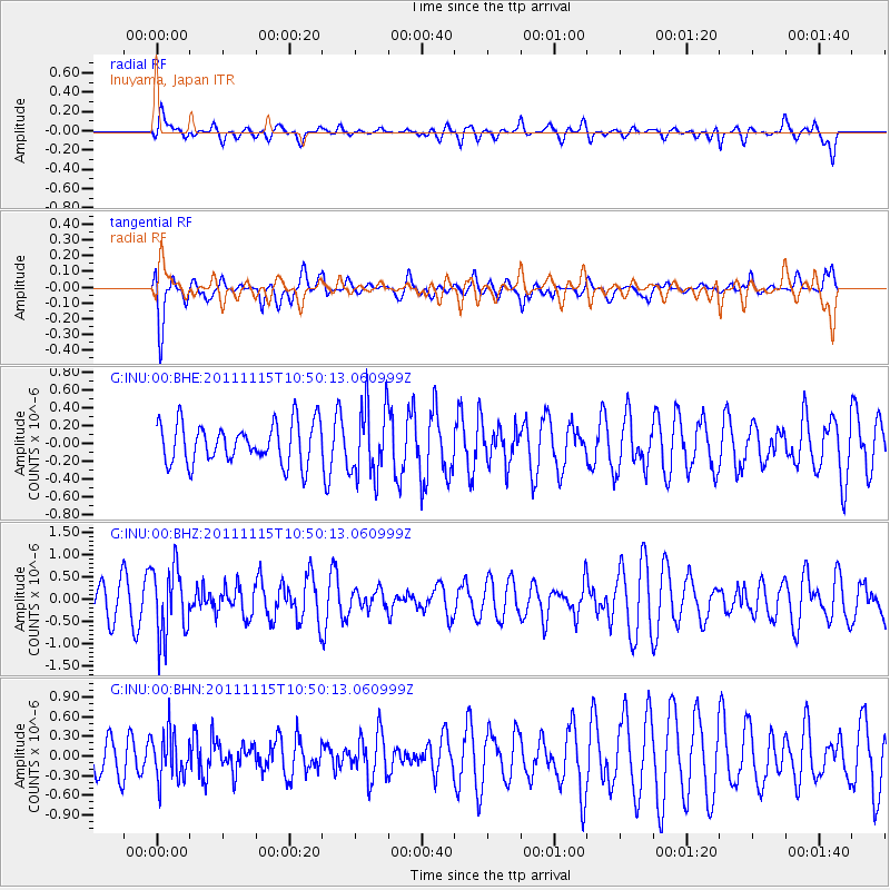
INU Inuyama, Japan - Earthquake Result Viewer
*The percent match for this event was below the threshold and hence no stack was calculated.
| Earthquake location: |
Minahassa Peninsula, Sulawesi |
| Earthquake latitude/longitude: |
-0.1/121.9 |
| Earthquake time(UTC): |
2011/11/15 (319) 10:43:51 GMT |
| Earthquake Depth: |
276 km |
| Earthquake Magnitude: |
5.7 MB, 5.7 MW, 5.8 MW |
| Earthquake Catalog/Contributor: |
WHDF/NEIC |
|
| Network: |
G GEOSCOPE |
| Station: |
INU Inuyama, Japan |
| Lat/Lon: |
35.35 N/137.03 E |
| Elevation: |
132 m |
|
| Distance: |
38.0 deg |
| Az: |
20.266 deg |
| Baz: |
205.071 deg |
| Ray Param: |
$rayparam |
*The percent match for this event was below the threshold and hence was not used in the summary stack. |
|
| Radial Match: |
43.663048 % |
| Radial Bump: |
400 |
| Transverse Match: |
61.37506 % |
| Transverse Bump: |
400 |
| SOD ConfigId: |
432046 |
| Insert Time: |
2012-02-28 05:55:29.001 +0000 |
| GWidth: |
2.5 |
| Max Bumps: |
400 |
| Tol: |
0.001 |
|
Signal To Noise
| Channel | StoN | STA | LTA |
| G:INU:00:BHZ:20111115T10:50:13.060999Z | 2.4038975 | 7.654092E-7 | 3.184034E-7 |
| G:INU:00:BHN:20111115T10:50:13.060999Z | 1.332335 | 3.5119064E-7 | 2.6359032E-7 |
| G:INU:00:BHE:20111115T10:50:13.060999Z | 1.7508067 | 3.9420783E-7 | 2.2515783E-7 |
| Arrivals |
| Ps | |
| PpPs | |
| PsPs/PpSs | |


