You are here: Home > Network List > G - GEOSCOPE Stations List
> Station HYB Hyderabad, India > Earthquake Result Viewer
HYB Hyderabad, India - Earthquake Result Viewer
| Earthquake location: |
North Of Halmahera, Indonesia |
| Earthquake latitude/longitude: |
4.0/128.2 |
| Earthquake time(UTC): |
1993/04/19 (109) 21:01:54 GMT |
| Earthquake Depth: |
70 km |
| Earthquake Magnitude: |
6.1 MB, 6.7 MS, 6.8 UNKNOWN |
| Earthquake Catalog/Contributor: |
WHDF/NEIC |
|
| Network: |
G GEOSCOPE |
| Station: |
HYB Hyderabad, India |
| Lat/Lon: |
17.42 N/78.55 E |
| Elevation: |
510 m |
|
| Distance: |
50.4 deg |
| Az: |
289.231 deg |
| Baz: |
99.397 deg |
| Ray Param: |
0.06787321 |
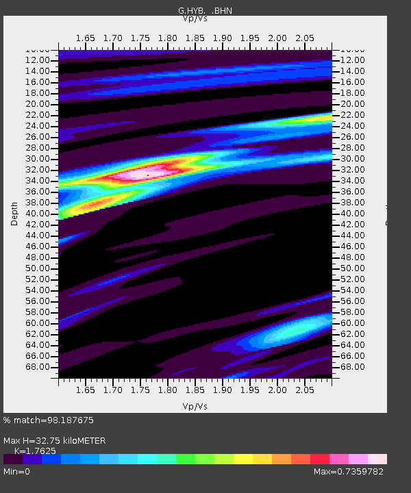
| Estimated Moho Depth: |
32.75 km |
| Estimated Crust Vp/Vs: |
1.76 |
| Assumed Crust Vp: |
6.459 km/s |
| Estimated Crust Vs: |
3.665 km/s |
| Estimated Crust Poisson's Ratio: |
0.26 |
|
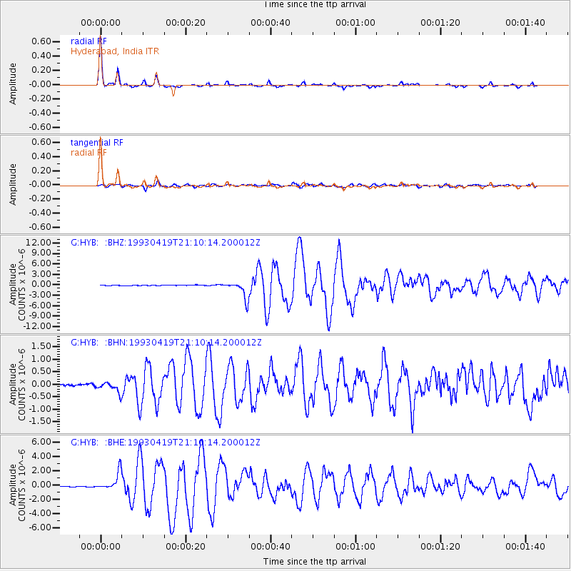
| Radial Match: |
98.187675 % |
| Radial Bump: |
193 |
| Transverse Match: |
90.316345 % |
| Transverse Bump: |
400 |
| SOD ConfigId: |
16938 |
| Insert Time: |
2010-02-26 22:49:53.952 +0000 |
| GWidth: |
2.5 |
| Max Bumps: |
400 |
| Tol: |
0.001 |
|
Signal To Noise
| Channel | StoN | STA | LTA |
| G:HYB: :BHN:19930419T21:10:14.200012Z | 5.558592 | 2.1305885E-7 | 3.8329645E-8 |
| G:HYB: :BHE:19930419T21:10:14.200012Z | 33.49083 | 1.3230567E-6 | 3.9505046E-8 |
| G:HYB: :BHZ:19930419T21:10:14.200012Z | 34.866234 | 2.6109346E-6 | 7.488433E-8 |
| Arrivals |
| Ps | 4.1 SECOND |
| PpPs | 13 SECOND |
| PsPs/PpSs | 17 SECOND |


