You are here: Home > Network List > CI - Caltech Regional Seismic Network Stations List
> Station SWS Sam W. Stewart, Westmorland, CA, USA > Earthquake Result Viewer
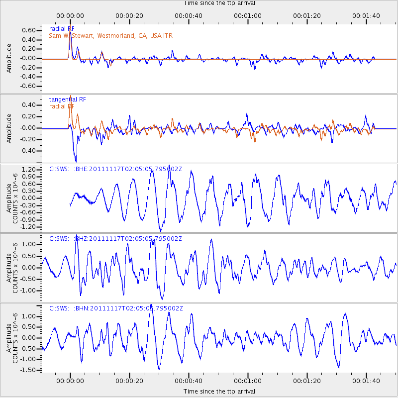
SWS Sam W. Stewart, Westmorland, CA, USA - Earthquake Result Viewer
*The percent match for this event was below the threshold and hence no stack was calculated.
| Earthquake location: |
Off Coast Of Ecuador |
| Earthquake latitude/longitude: |
-1.7/-81.5 |
| Earthquake time(UTC): |
2011/11/17 (321) 01:57:05 GMT |
| Earthquake Depth: |
27 km |
| Earthquake Magnitude: |
5.7 MB, 5.6 MS, 6.0 MW, 5.9 MW |
| Earthquake Catalog/Contributor: |
WHDF/NEIC |
|
| Network: |
CI Caltech Regional Seismic Network |
| Station: |
SWS Sam W. Stewart, Westmorland, CA, USA |
| Lat/Lon: |
32.94 N/115.80 W |
| Elevation: |
140 m |
|
| Distance: |
47.2 deg |
| Az: |
319.873 deg |
| Baz: |
129.995 deg |
| Ray Param: |
$rayparam |
*The percent match for this event was below the threshold and hence was not used in the summary stack. |
|
| Radial Match: |
41.002747 % |
| Radial Bump: |
286 |
| Transverse Match: |
52.13676 % |
| Transverse Bump: |
342 |
| SOD ConfigId: |
432046 |
| Insert Time: |
2012-02-28 06:14:59.666 +0000 |
| GWidth: |
2.5 |
| Max Bumps: |
400 |
| Tol: |
0.001 |
|
Signal To Noise
| Channel | StoN | STA | LTA |
| CI:SWS: :BHZ:20111117T02:05:05.795002Z | 2.4632852 | 6.862486E-7 | 2.785908E-7 |
| CI:SWS: :BHN:20111117T02:05:05.795002Z | 1.1679143 | 4.19488E-7 | 3.5917705E-7 |
| CI:SWS: :BHE:20111117T02:05:05.795002Z | 2.1752958 | 9.082052E-7 | 4.175088E-7 |
| Arrivals |
| Ps | |
| PpPs | |
| PsPs/PpSs | |


