You are here: Home > Network List > IU - Global Seismograph Network (GSN - IRIS/USGS) Stations List
> Station GRFO Grafenberg, Germany > Earthquake Result Viewer
GRFO Grafenberg, Germany - Earthquake Result Viewer
*The percent match for this event was below the threshold and hence no stack was calculated.
| Earthquake location: |
Off Coast Of Ecuador |
| Earthquake latitude/longitude: |
-1.7/-81.5 |
| Earthquake time(UTC): |
2011/11/17 (321) 01:57:05 GMT |
| Earthquake Depth: |
27 km |
| Earthquake Magnitude: |
5.7 MB, 5.6 MS, 6.0 MW, 5.9 MW |
| Earthquake Catalog/Contributor: |
WHDF/NEIC |
|
| Network: |
IU Global Seismograph Network (GSN - IRIS/USGS) |
| Station: |
GRFO Grafenberg, Germany |
| Lat/Lon: |
49.69 N/11.22 E |
| Elevation: |
384 m |
|
| Distance: |
93.1 deg |
| Az: |
40.513 deg |
| Baz: |
271.006 deg |
| Ray Param: |
$rayparam |
*The percent match for this event was below the threshold and hence was not used in the summary stack. |
|
| Radial Match: |
49.457375 % |
| Radial Bump: |
350 |
| Transverse Match: |
45.860752 % |
| Transverse Bump: |
359 |
| SOD ConfigId: |
432046 |
| Insert Time: |
2012-02-28 06:18:15.203 +0000 |
| GWidth: |
2.5 |
| Max Bumps: |
400 |
| Tol: |
0.001 |
|
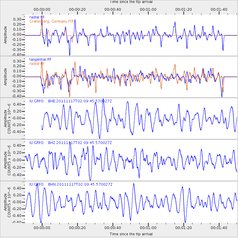
Signal To Noise
| Channel | StoN | STA | LTA |
| IU:GRFO: :BHZ:20111117T02:09:45.570027Z | 1.3086516 | 1.6420762E-7 | 1.254785E-7 |
| IU:GRFO: :BHN:20111117T02:09:45.570027Z | 2.0724926 | 3.4842216E-7 | 1.6811744E-7 |
| IU:GRFO: :BHE:20111117T02:09:45.570027Z | 1.9963024 | 3.7661835E-7 | 1.8865796E-7 |
| Arrivals |
| Ps | |
| PpPs | |
| PsPs/PpSs | |


