You are here: Home > Network List > TA - USArray Transportable Network (new EarthScope stations) Stations List
> Station M04C Macdoel, CA, USA > Earthquake Result Viewer
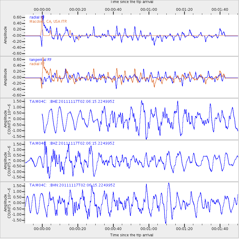
M04C Macdoel, CA, USA - Earthquake Result Viewer
*The percent match for this event was below the threshold and hence no stack was calculated.
| Earthquake location: |
Off Coast Of Ecuador |
| Earthquake latitude/longitude: |
-1.7/-81.5 |
| Earthquake time(UTC): |
2011/11/17 (321) 01:57:05 GMT |
| Earthquake Depth: |
27 km |
| Earthquake Magnitude: |
5.7 MB, 5.6 MS, 6.0 MW, 5.9 MW |
| Earthquake Catalog/Contributor: |
WHDF/NEIC |
|
| Network: |
TA USArray Transportable Network (new EarthScope stations) |
| Station: |
M04C Macdoel, CA, USA |
| Lat/Lon: |
41.78 N/121.84 W |
| Elevation: |
1391 m |
|
| Distance: |
56.6 deg |
| Az: |
324.591 deg |
| Baz: |
129.251 deg |
| Ray Param: |
$rayparam |
*The percent match for this event was below the threshold and hence was not used in the summary stack. |
|
| Radial Match: |
66.52542 % |
| Radial Bump: |
400 |
| Transverse Match: |
57.706062 % |
| Transverse Bump: |
400 |
| SOD ConfigId: |
432046 |
| Insert Time: |
2012-02-28 06:21:16.525 +0000 |
| GWidth: |
2.5 |
| Max Bumps: |
400 |
| Tol: |
0.001 |
|
Signal To Noise
| Channel | StoN | STA | LTA |
| TA:M04C: :BHZ:20111117T02:06:15.224995Z | 1.9842463 | 9.133436E-7 | 4.602975E-7 |
| TA:M04C: :BHN:20111117T02:06:15.224995Z | 1.4696445 | 6.6882336E-7 | 4.5509194E-7 |
| TA:M04C: :BHE:20111117T02:06:15.224995Z | 0.7668832 | 4.777401E-7 | 6.229633E-7 |
| Arrivals |
| Ps | |
| PpPs | |
| PsPs/PpSs | |


