You are here: Home > Network List > TA - USArray Transportable Network (new EarthScope stations) Stations List
> Station 435B Jarrell, TX, USA > Earthquake Result Viewer
435B Jarrell, TX, USA - Earthquake Result Viewer
| Earthquake location: |
Off Coast Of Ecuador |
| Earthquake latitude/longitude: |
-1.7/-81.5 |
| Earthquake time(UTC): |
2011/11/17 (321) 01:57:05 GMT |
| Earthquake Depth: |
27 km |
| Earthquake Magnitude: |
5.7 MB, 5.6 MS, 6.0 MW, 5.9 MW |
| Earthquake Catalog/Contributor: |
WHDF/NEIC |
|
| Network: |
TA USArray Transportable Network (new EarthScope stations) |
| Station: |
435B Jarrell, TX, USA |
| Lat/Lon: |
30.78 N/97.58 W |
| Elevation: |
248 m |
|
| Distance: |
35.7 deg |
| Az: |
335.975 deg |
| Baz: |
151.779 deg |
| Ray Param: |
0.07702057 |
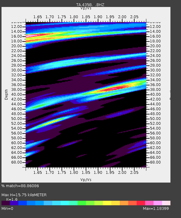
| Estimated Moho Depth: |
15.75 km |
| Estimated Crust Vp/Vs: |
1.60 |
| Assumed Crust Vp: |
6.347 km/s |
| Estimated Crust Vs: |
3.967 km/s |
| Estimated Crust Poisson's Ratio: |
0.18 |
|
| Radial Match: |
88.86086 % |
| Radial Bump: |
400 |
| Transverse Match: |
75.07247 % |
| Transverse Bump: |
400 |
| SOD ConfigId: |
432046 |
| Insert Time: |
2012-02-28 06:24:00.471 +0000 |
| GWidth: |
2.5 |
| Max Bumps: |
400 |
| Tol: |
0.001 |
|
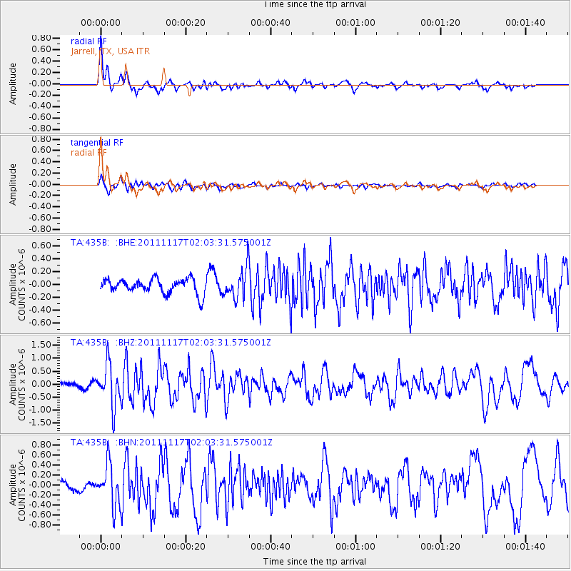
Signal To Noise
| Channel | StoN | STA | LTA |
| TA:435B: :BHZ:20111117T02:03:31.575001Z | 7.544907 | 8.16394E-7 | 1.0820464E-7 |
| TA:435B: :BHN:20111117T02:03:31.575001Z | 3.921951 | 4.2896932E-7 | 1.09376515E-7 |
| TA:435B: :BHE:20111117T02:03:31.575001Z | 2.131255 | 2.3901308E-7 | 1.1214664E-7 |
| Arrivals |
| Ps | 1.6 SECOND |
| PpPs | 5.9 SECOND |
| PsPs/PpSs | 7.6 SECOND |


