You are here: Home > Network List > TA - USArray Transportable Network (new EarthScope stations) Stations List
> Station O36A Bolckow, MO, USA > Earthquake Result Viewer
O36A Bolckow, MO, USA - Earthquake Result Viewer
| Earthquake location: |
Off Coast Of Ecuador |
| Earthquake latitude/longitude: |
-1.7/-81.5 |
| Earthquake time(UTC): |
2011/11/17 (321) 01:57:05 GMT |
| Earthquake Depth: |
27 km |
| Earthquake Magnitude: |
5.7 MB, 5.6 MS, 6.0 MW, 5.9 MW |
| Earthquake Catalog/Contributor: |
WHDF/NEIC |
|
| Network: |
TA USArray Transportable Network (new EarthScope stations) |
| Station: |
O36A Bolckow, MO, USA |
| Lat/Lon: |
40.13 N/94.96 W |
| Elevation: |
306 m |
|
| Distance: |
43.4 deg |
| Az: |
344.994 deg |
| Baz: |
160.272 deg |
| Ray Param: |
0.07252543 |
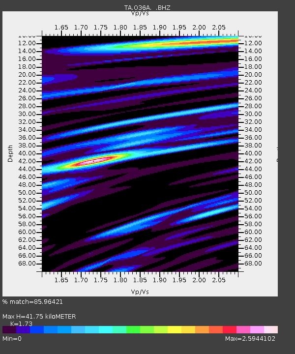
| Estimated Moho Depth: |
41.75 km |
| Estimated Crust Vp/Vs: |
1.73 |
| Assumed Crust Vp: |
6.498 km/s |
| Estimated Crust Vs: |
3.756 km/s |
| Estimated Crust Poisson's Ratio: |
0.25 |
|
| Radial Match: |
85.96421 % |
| Radial Bump: |
400 |
| Transverse Match: |
66.77122 % |
| Transverse Bump: |
400 |
| SOD ConfigId: |
432046 |
| Insert Time: |
2012-02-28 06:27:55.864 +0000 |
| GWidth: |
2.5 |
| Max Bumps: |
400 |
| Tol: |
0.001 |
|

Signal To Noise
| Channel | StoN | STA | LTA |
| TA:O36A: :BHZ:20111117T02:04:35.349995Z | 8.190789 | 8.559803E-7 | 1.04505226E-7 |
| TA:O36A: :BHN:20111117T02:04:35.349995Z | 3.7522368 | 8.2753076E-7 | 2.2054331E-7 |
| TA:O36A: :BHE:20111117T02:04:35.349995Z | 2.0431497 | 3.8001767E-7 | 1.8599599E-7 |
| Arrivals |
| Ps | 5.0 SECOND |
| PpPs | 16 SECOND |
| PsPs/PpSs | 21 SECOND |


