You are here: Home > Network List > TA - USArray Transportable Network (new EarthScope stations) Stations List
> Station V37A Hulbert, OK, USA > Earthquake Result Viewer
V37A Hulbert, OK, USA - Earthquake Result Viewer

| Earthquake location: |
Off Coast Of Ecuador |
| Earthquake latitude/longitude: |
-1.7/-81.5 |
| Earthquake time(UTC): |
2011/11/17 (321) 01:57:05 GMT |
| Earthquake Depth: |
27 km |
| Earthquake Magnitude: |
5.7 MB, 5.6 MS, 6.0 MW, 5.9 MW |
| Earthquake Catalog/Contributor: |
WHDF/NEIC |
|
| Network: |
TA USArray Transportable Network (new EarthScope stations) |
| Station: |
V37A Hulbert, OK, USA |
| Lat/Lon: |
35.88 N/95.14 W |
| Elevation: |
219 m |
|
| Distance: |
39.5 deg |
| Az: |
342.532 deg |
| Baz: |
158.316 deg |
| Ray Param: |
0.07491135 |
| Estimated Moho Depth: |
42.75 km |
| Estimated Crust Vp/Vs: |
1.75 |
| Assumed Crust Vp: |
6.498 km/s |
| Estimated Crust Vs: |
3.718 km/s |
| Estimated Crust Poisson's Ratio: |
0.26 |
|
| Radial Match: |
86.480705 % |
| Radial Bump: |
369 |
| Transverse Match: |
53.882713 % |
| Transverse Bump: |
378 |
| SOD ConfigId: |
432046 |
| Insert Time: |
2012-02-28 06:29:11.897 +0000 |
| GWidth: |
2.5 |
| Max Bumps: |
400 |
| Tol: |
0.001 |
|
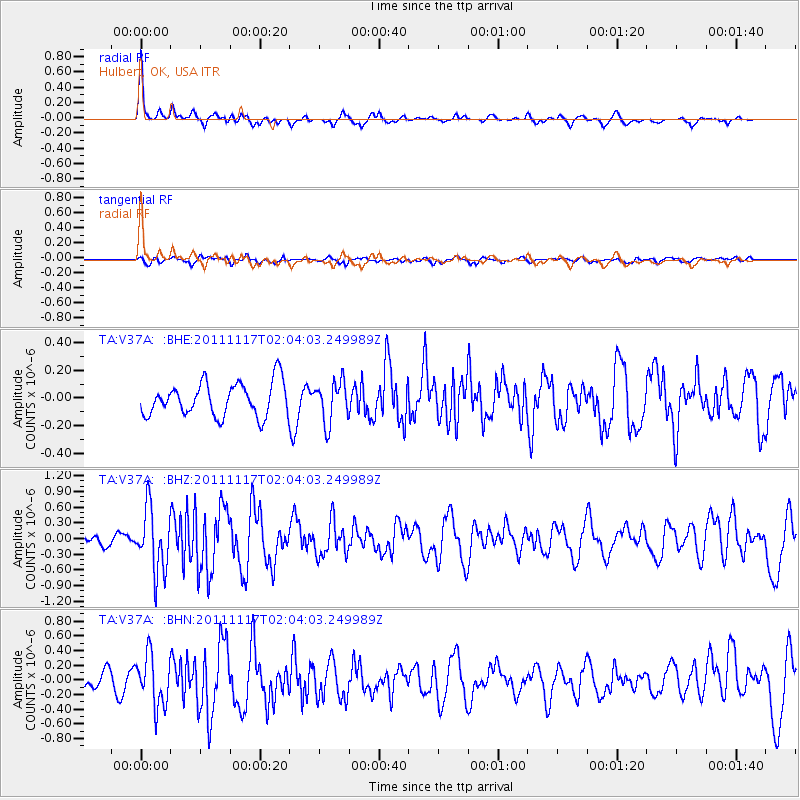
Signal To Noise
| Channel | StoN | STA | LTA |
| TA:V37A: :BHZ:20111117T02:04:03.249989Z | 6.391875 | 5.991985E-7 | 9.374378E-8 |
| TA:V37A: :BHN:20111117T02:04:03.249989Z | 3.1304905 | 3.4470094E-7 | 1.1011084E-7 |
| TA:V37A: :BHE:20111117T02:04:03.249989Z | 1.2466435 | 1.4919361E-7 | 1.1967624E-7 |
| Arrivals |
| Ps | 5.3 SECOND |
| PpPs | 17 SECOND |
| PsPs/PpSs | 22 SECOND |


