You are here: Home > Network List > TA - USArray Transportable Network (new EarthScope stations) Stations List
> Station U37A Salina, OK, USA > Earthquake Result Viewer
U37A Salina, OK, USA - Earthquake Result Viewer

| Earthquake location: |
Off Coast Of Ecuador |
| Earthquake latitude/longitude: |
-1.7/-81.5 |
| Earthquake time(UTC): |
2011/11/17 (321) 01:57:05 GMT |
| Earthquake Depth: |
27 km |
| Earthquake Magnitude: |
5.7 MB, 5.6 MS, 6.0 MW, 5.9 MW |
| Earthquake Catalog/Contributor: |
WHDF/NEIC |
|
| Network: |
TA USArray Transportable Network (new EarthScope stations) |
| Station: |
U37A Salina, OK, USA |
| Lat/Lon: |
36.41 N/95.12 W |
| Elevation: |
248 m |
|
| Distance: |
40.0 deg |
| Az: |
342.861 deg |
| Baz: |
158.584 deg |
| Ray Param: |
0.0746244 |
| Estimated Moho Depth: |
22.75 km |
| Estimated Crust Vp/Vs: |
1.65 |
| Assumed Crust Vp: |
6.53 km/s |
| Estimated Crust Vs: |
3.964 km/s |
| Estimated Crust Poisson's Ratio: |
0.21 |
|
| Radial Match: |
85.25832 % |
| Radial Bump: |
330 |
| Transverse Match: |
57.437843 % |
| Transverse Bump: |
400 |
| SOD ConfigId: |
432046 |
| Insert Time: |
2012-02-28 06:29:35.769 +0000 |
| GWidth: |
2.5 |
| Max Bumps: |
400 |
| Tol: |
0.001 |
|
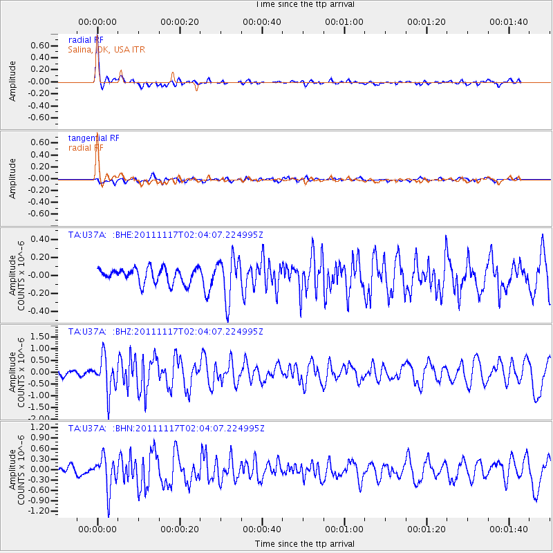
Signal To Noise
| Channel | StoN | STA | LTA |
| TA:U37A: :BHZ:20111117T02:04:07.224995Z | 6.318723 | 7.559406E-7 | 1.1963503E-7 |
| TA:U37A: :BHN:20111117T02:04:07.224995Z | 4.750082 | 4.8338376E-7 | 1.0176325E-7 |
| TA:U37A: :BHE:20111117T02:04:07.224995Z | 2.8940005 | 2.3806292E-7 | 8.226084E-8 |
| Arrivals |
| Ps | 2.4 SECOND |
| PpPs | 8.5 SECOND |
| PsPs/PpSs | 11 SECOND |


