You are here: Home > Network List > TA - USArray Transportable Network (new EarthScope stations) Stations List
> Station U35A Pawnee, OK, USA > Earthquake Result Viewer
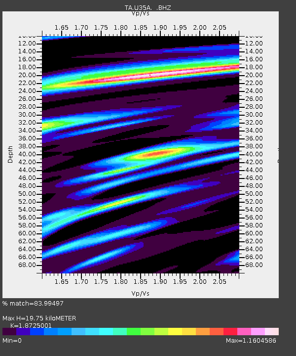
U35A Pawnee, OK, USA - Earthquake Result Viewer
| Earthquake location: |
Off Coast Of Ecuador |
| Earthquake latitude/longitude: |
-1.7/-81.5 |
| Earthquake time(UTC): |
2011/11/17 (321) 01:57:05 GMT |
| Earthquake Depth: |
27 km |
| Earthquake Magnitude: |
5.7 MB, 5.6 MS, 6.0 MW, 5.9 MW |
| Earthquake Catalog/Contributor: |
WHDF/NEIC |
|
| Network: |
TA USArray Transportable Network (new EarthScope stations) |
| Station: |
U35A Pawnee, OK, USA |
| Lat/Lon: |
36.37 N/96.73 W |
| Elevation: |
303 m |
|
| Distance: |
40.4 deg |
| Az: |
340.976 deg |
| Baz: |
156.19 deg |
| Ray Param: |
0.07435974 |
| Estimated Moho Depth: |
19.75 km |
| Estimated Crust Vp/Vs: |
1.87 |
| Assumed Crust Vp: |
6.483 km/s |
| Estimated Crust Vs: |
3.462 km/s |
| Estimated Crust Poisson's Ratio: |
0.30 |
|
| Radial Match: |
83.99497 % |
| Radial Bump: |
361 |
| Transverse Match: |
48.781788 % |
| Transverse Bump: |
392 |
| SOD ConfigId: |
432046 |
| Insert Time: |
2012-02-28 06:29:49.148 +0000 |
| GWidth: |
2.5 |
| Max Bumps: |
400 |
| Tol: |
0.001 |
|

Signal To Noise
| Channel | StoN | STA | LTA |
| TA:U35A: :BHZ:20111117T02:04:11.099995Z | 5.7688856 | 8.17689E-7 | 1.4174124E-7 |
| TA:U35A: :BHN:20111117T02:04:11.099995Z | 5.4805446 | 7.6951886E-7 | 1.4040918E-7 |
| TA:U35A: :BHE:20111117T02:04:11.099995Z | 2.1583679 | 2.8882718E-7 | 1.3381741E-7 |
| Arrivals |
| Ps | 2.8 SECOND |
| PpPs | 8.2 SECOND |
| PsPs/PpSs | 11 SECOND |


