You are here: Home > Network List > TA - USArray Transportable Network (new EarthScope stations) Stations List
> Station K33A Hardington, NE, USA > Earthquake Result Viewer
K33A Hardington, NE, USA - Earthquake Result Viewer
| Earthquake location: |
Off Coast Of Ecuador |
| Earthquake latitude/longitude: |
-1.7/-81.5 |
| Earthquake time(UTC): |
2011/11/17 (321) 01:57:05 GMT |
| Earthquake Depth: |
27 km |
| Earthquake Magnitude: |
5.7 MB, 5.6 MS, 6.0 MW, 5.9 MW |
| Earthquake Catalog/Contributor: |
WHDF/NEIC |
|
| Network: |
TA USArray Transportable Network (new EarthScope stations) |
| Station: |
K33A Hardington, NE, USA |
| Lat/Lon: |
42.61 N/97.00 W |
| Elevation: |
507 m |
|
| Distance: |
46.3 deg |
| Az: |
344.198 deg |
| Baz: |
158.365 deg |
| Ray Param: |
0.070710324 |
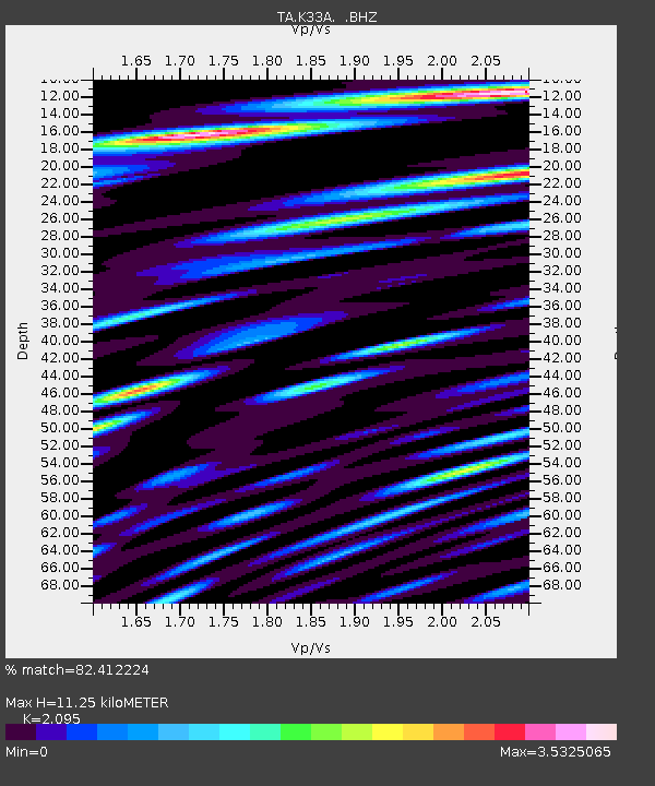
| Estimated Moho Depth: |
11.25 km |
| Estimated Crust Vp/Vs: |
2.10 |
| Assumed Crust Vp: |
6.498 km/s |
| Estimated Crust Vs: |
3.101 km/s |
| Estimated Crust Poisson's Ratio: |
0.35 |
|
| Radial Match: |
82.412224 % |
| Radial Bump: |
400 |
| Transverse Match: |
69.817024 % |
| Transverse Bump: |
400 |
| SOD ConfigId: |
432046 |
| Insert Time: |
2012-02-28 06:30:03.032 +0000 |
| GWidth: |
2.5 |
| Max Bumps: |
400 |
| Tol: |
0.001 |
|
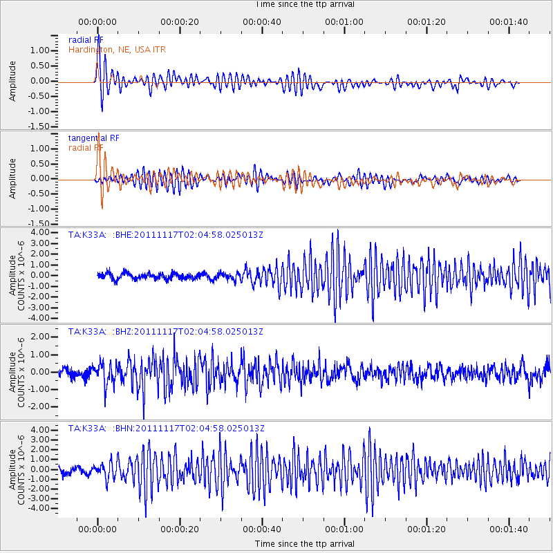
Signal To Noise
| Channel | StoN | STA | LTA |
| TA:K33A: :BHZ:20111117T02:04:58.025013Z | 2.9319274 | 5.893669E-7 | 2.0101687E-7 |
| TA:K33A: :BHN:20111117T02:04:58.025013Z | 2.7113626 | 8.081604E-7 | 2.980643E-7 |
| TA:K33A: :BHE:20111117T02:04:58.025013Z | 1.1257454 | 3.1401768E-7 | 2.78942E-7 |
| Arrivals |
| Ps | 2.0 SECOND |
| PpPs | 5.1 SECOND |
| PsPs/PpSs | 7.1 SECOND |


