You are here: Home > Network List > TA - USArray Transportable Network (new EarthScope stations) Stations List
> Station I31A Royce, Wessington Springs, SD, USA > Earthquake Result Viewer
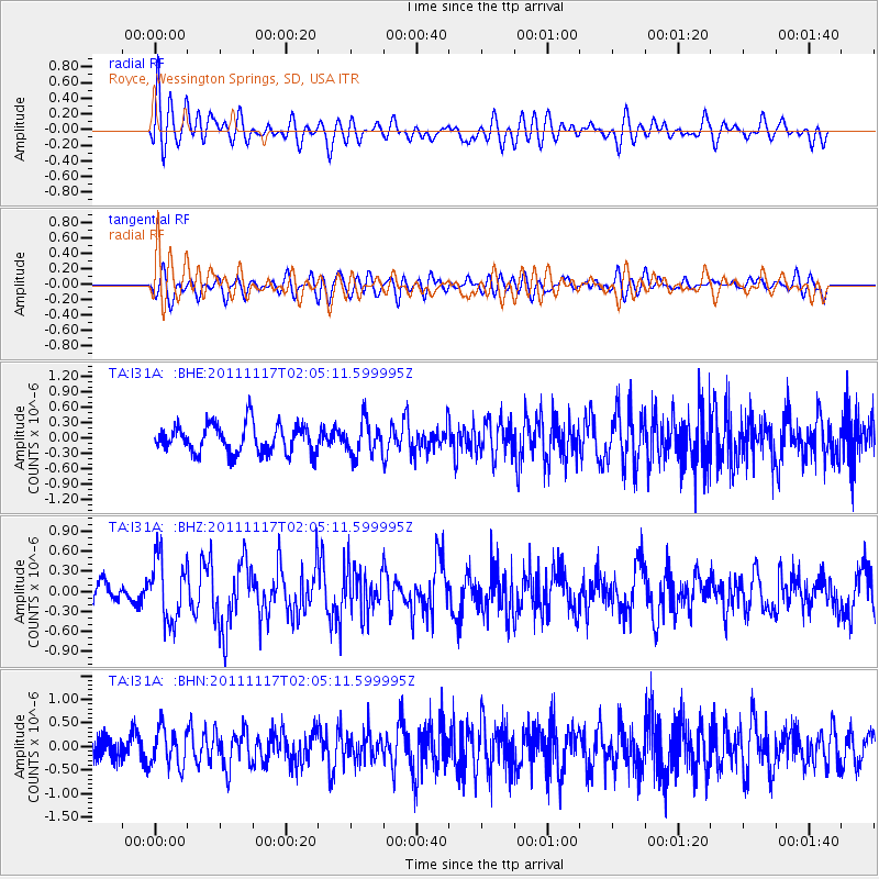
I31A Royce, Wessington Springs, SD, USA - Earthquake Result Viewer
*The percent match for this event was below the threshold and hence no stack was calculated.
| Earthquake location: |
Off Coast Of Ecuador |
| Earthquake latitude/longitude: |
-1.7/-81.5 |
| Earthquake time(UTC): |
2011/11/17 (321) 01:57:05 GMT |
| Earthquake Depth: |
27 km |
| Earthquake Magnitude: |
5.7 MB, 5.6 MS, 6.0 MW, 5.9 MW |
| Earthquake Catalog/Contributor: |
WHDF/NEIC |
|
| Network: |
TA USArray Transportable Network (new EarthScope stations) |
| Station: |
I31A Royce, Wessington Springs, SD, USA |
| Lat/Lon: |
44.03 N/98.54 W |
| Elevation: |
469 m |
|
| Distance: |
48.0 deg |
| Az: |
343.525 deg |
| Baz: |
156.859 deg |
| Ray Param: |
$rayparam |
*The percent match for this event was below the threshold and hence was not used in the summary stack. |
|
| Radial Match: |
65.84126 % |
| Radial Bump: |
400 |
| Transverse Match: |
61.12789 % |
| Transverse Bump: |
400 |
| SOD ConfigId: |
432046 |
| Insert Time: |
2012-02-28 06:30:15.778 +0000 |
| GWidth: |
2.5 |
| Max Bumps: |
400 |
| Tol: |
0.001 |
|
Signal To Noise
| Channel | StoN | STA | LTA |
| TA:I31A: :BHZ:20111117T02:05:11.599995Z | 2.479095 | 4.6863258E-7 | 1.8903373E-7 |
| TA:I31A: :BHN:20111117T02:05:11.599995Z | 1.4627198 | 3.9813222E-7 | 2.7218624E-7 |
| TA:I31A: :BHE:20111117T02:05:11.599995Z | 1.185923 | 3.2875633E-7 | 2.7721558E-7 |
| Arrivals |
| Ps | |
| PpPs | |
| PsPs/PpSs | |


