You are here: Home > Network List > TA - USArray Transportable Network (new EarthScope stations) Stations List
> Station E33A Westby DABS, Erhard, MN, USA > Earthquake Result Viewer
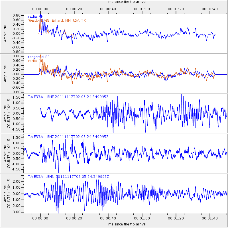
E33A Westby DABS, Erhard, MN, USA - Earthquake Result Viewer
*The percent match for this event was below the threshold and hence no stack was calculated.
| Earthquake location: |
Off Coast Of Ecuador |
| Earthquake latitude/longitude: |
-1.7/-81.5 |
| Earthquake time(UTC): |
2011/11/17 (321) 01:57:05 GMT |
| Earthquake Depth: |
27 km |
| Earthquake Magnitude: |
5.7 MB, 5.6 MS, 6.0 MW, 5.9 MW |
| Earthquake Catalog/Contributor: |
WHDF/NEIC |
|
| Network: |
TA USArray Transportable Network (new EarthScope stations) |
| Station: |
E33A Westby DABS, Erhard, MN, USA |
| Lat/Lon: |
46.50 N/96.01 W |
| Elevation: |
428 m |
|
| Distance: |
49.7 deg |
| Az: |
346.923 deg |
| Baz: |
160.888 deg |
| Ray Param: |
$rayparam |
*The percent match for this event was below the threshold and hence was not used in the summary stack. |
|
| Radial Match: |
58.94361 % |
| Radial Bump: |
400 |
| Transverse Match: |
60.54978 % |
| Transverse Bump: |
400 |
| SOD ConfigId: |
432046 |
| Insert Time: |
2012-02-28 06:32:14.400 +0000 |
| GWidth: |
2.5 |
| Max Bumps: |
400 |
| Tol: |
0.001 |
|
Signal To Noise
| Channel | StoN | STA | LTA |
| TA:E33A: :BHZ:20111117T02:05:24.349995Z | 1.7585008 | 4.742617E-7 | 2.696966E-7 |
| TA:E33A: :BHN:20111117T02:05:24.349995Z | 2.0101218 | 6.3652607E-7 | 3.1666042E-7 |
| TA:E33A: :BHE:20111117T02:05:24.349995Z | 1.13549 | 3.347301E-7 | 2.9478912E-7 |
| Arrivals |
| Ps | |
| PpPs | |
| PsPs/PpSs | |


