You are here: Home > Network List > TA - USArray Transportable Network (new EarthScope stations) Stations List
> Station K36A Gilmore City, IA, USA > Earthquake Result Viewer
K36A Gilmore City, IA, USA - Earthquake Result Viewer
*The percent match for this event was below the threshold and hence no stack was calculated.
| Earthquake location: |
Off Coast Of Ecuador |
| Earthquake latitude/longitude: |
-1.7/-81.5 |
| Earthquake time(UTC): |
2011/11/17 (321) 01:57:05 GMT |
| Earthquake Depth: |
27 km |
| Earthquake Magnitude: |
5.7 MB, 5.6 MS, 6.0 MW, 5.9 MW |
| Earthquake Catalog/Contributor: |
WHDF/NEIC |
|
| Network: |
TA USArray Transportable Network (new EarthScope stations) |
| Station: |
K36A Gilmore City, IA, USA |
| Lat/Lon: |
42.64 N/94.45 W |
| Elevation: |
364 m |
|
| Distance: |
45.6 deg |
| Az: |
346.676 deg |
| Baz: |
161.809 deg |
| Ray Param: |
$rayparam |
*The percent match for this event was below the threshold and hence was not used in the summary stack. |
|
| Radial Match: |
76.34979 % |
| Radial Bump: |
400 |
| Transverse Match: |
78.287704 % |
| Transverse Bump: |
400 |
| SOD ConfigId: |
432046 |
| Insert Time: |
2012-02-28 06:34:52.255 +0000 |
| GWidth: |
2.5 |
| Max Bumps: |
400 |
| Tol: |
0.001 |
|
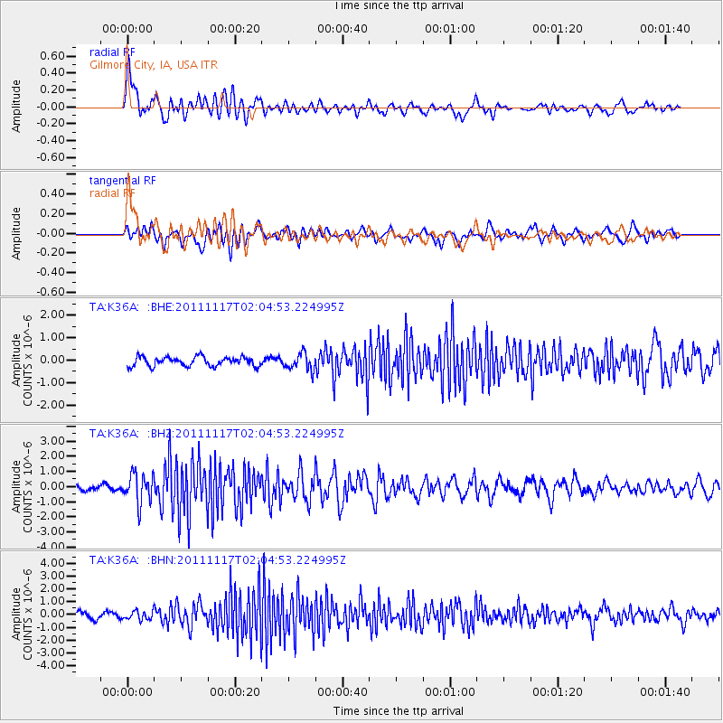
Signal To Noise
| Channel | StoN | STA | LTA |
| TA:K36A: :BHZ:20111117T02:04:53.224995Z | 3.9244914 | 9.816015E-7 | 2.5012199E-7 |
| TA:K36A: :BHN:20111117T02:04:53.224995Z | 1.2325929 | 3.409419E-7 | 2.7660545E-7 |
| TA:K36A: :BHE:20111117T02:04:53.224995Z | 1.7893541 | 3.7224117E-7 | 2.0803103E-7 |
| Arrivals |
| Ps | |
| PpPs | |
| PsPs/PpSs | |


