You are here: Home > Network List > TA - USArray Transportable Network (new EarthScope stations) Stations List
> Station R38A Fenwick Farm, Montrose, MO, USA > Earthquake Result Viewer
R38A Fenwick Farm, Montrose, MO, USA - Earthquake Result Viewer
| Earthquake location: |
Off Coast Of Ecuador |
| Earthquake latitude/longitude: |
-1.7/-81.5 |
| Earthquake time(UTC): |
2011/11/17 (321) 01:57:05 GMT |
| Earthquake Depth: |
27 km |
| Earthquake Magnitude: |
5.7 MB, 5.6 MS, 6.0 MW, 5.9 MW |
| Earthquake Catalog/Contributor: |
WHDF/NEIC |
|
| Network: |
TA USArray Transportable Network (new EarthScope stations) |
| Station: |
R38A Fenwick Farm, Montrose, MO, USA |
| Lat/Lon: |
38.19 N/93.91 W |
| Elevation: |
237 m |
|
| Distance: |
41.3 deg |
| Az: |
345.194 deg |
| Baz: |
161.085 deg |
| Ray Param: |
0.0738305 |
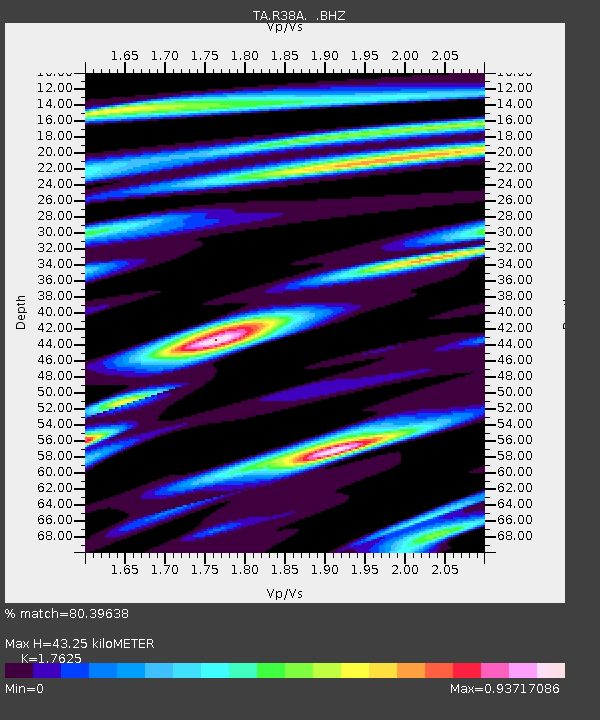
| Estimated Moho Depth: |
43.25 km |
| Estimated Crust Vp/Vs: |
1.76 |
| Assumed Crust Vp: |
6.498 km/s |
| Estimated Crust Vs: |
3.687 km/s |
| Estimated Crust Poisson's Ratio: |
0.26 |
|
| Radial Match: |
80.39638 % |
| Radial Bump: |
343 |
| Transverse Match: |
53.958866 % |
| Transverse Bump: |
400 |
| SOD ConfigId: |
432046 |
| Insert Time: |
2012-02-28 06:36:29.593 +0000 |
| GWidth: |
2.5 |
| Max Bumps: |
400 |
| Tol: |
0.001 |
|

Signal To Noise
| Channel | StoN | STA | LTA |
| TA:R38A: :BHZ:20111117T02:04:18.224995Z | 5.798502 | 6.4230454E-7 | 1.1077078E-7 |
| TA:R38A: :BHN:20111117T02:04:18.224995Z | 2.435099 | 3.9587795E-7 | 1.6257162E-7 |
| TA:R38A: :BHE:20111117T02:04:18.224995Z | 0.8894812 | 1.2744465E-7 | 1.4327975E-7 |
| Arrivals |
| Ps | 5.4 SECOND |
| PpPs | 17 SECOND |
| PsPs/PpSs | 23 SECOND |


