You are here: Home > Network List > TA - USArray Transportable Network (new EarthScope stations) Stations List
> Station 140A Cam and Jess, Hughton, LA, USA > Earthquake Result Viewer
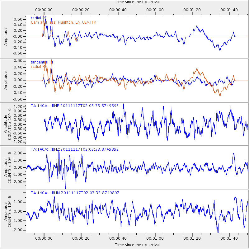
140A Cam and Jess, Hughton, LA, USA - Earthquake Result Viewer
*The percent match for this event was below the threshold and hence no stack was calculated.
| Earthquake location: |
Off Coast Of Ecuador |
| Earthquake latitude/longitude: |
-1.7/-81.5 |
| Earthquake time(UTC): |
2011/11/17 (321) 01:57:05 GMT |
| Earthquake Depth: |
27 km |
| Earthquake Magnitude: |
5.7 MB, 5.6 MS, 6.0 MW, 5.9 MW |
| Earthquake Catalog/Contributor: |
WHDF/NEIC |
|
| Network: |
TA USArray Transportable Network (new EarthScope stations) |
| Station: |
140A Cam and Jess, Hughton, LA, USA |
| Lat/Lon: |
32.64 N/93.57 W |
| Elevation: |
56 m |
|
| Distance: |
36.0 deg |
| Az: |
342.596 deg |
| Baz: |
159.246 deg |
| Ray Param: |
$rayparam |
*The percent match for this event was below the threshold and hence was not used in the summary stack. |
|
| Radial Match: |
69.59132 % |
| Radial Bump: |
400 |
| Transverse Match: |
47.786873 % |
| Transverse Bump: |
400 |
| SOD ConfigId: |
432046 |
| Insert Time: |
2012-02-28 06:38:51.472 +0000 |
| GWidth: |
2.5 |
| Max Bumps: |
400 |
| Tol: |
0.001 |
|
Signal To Noise
| Channel | StoN | STA | LTA |
| TA:140A: :BHZ:20111117T02:03:33.874989Z | 3.820097 | 8.8443045E-7 | 2.3152043E-7 |
| TA:140A: :BHN:20111117T02:03:33.874989Z | 1.2106261 | 7.9234394E-7 | 6.5449103E-7 |
| TA:140A: :BHE:20111117T02:03:33.874989Z | 0.973535 | 3.2621696E-7 | 3.35085E-7 |
| Arrivals |
| Ps | |
| PpPs | |
| PsPs/PpSs | |


