You are here: Home > Network List > TA - USArray Transportable Network (new EarthScope stations) Stations List
> Station V45A Humboldt, TN, USA > Earthquake Result Viewer
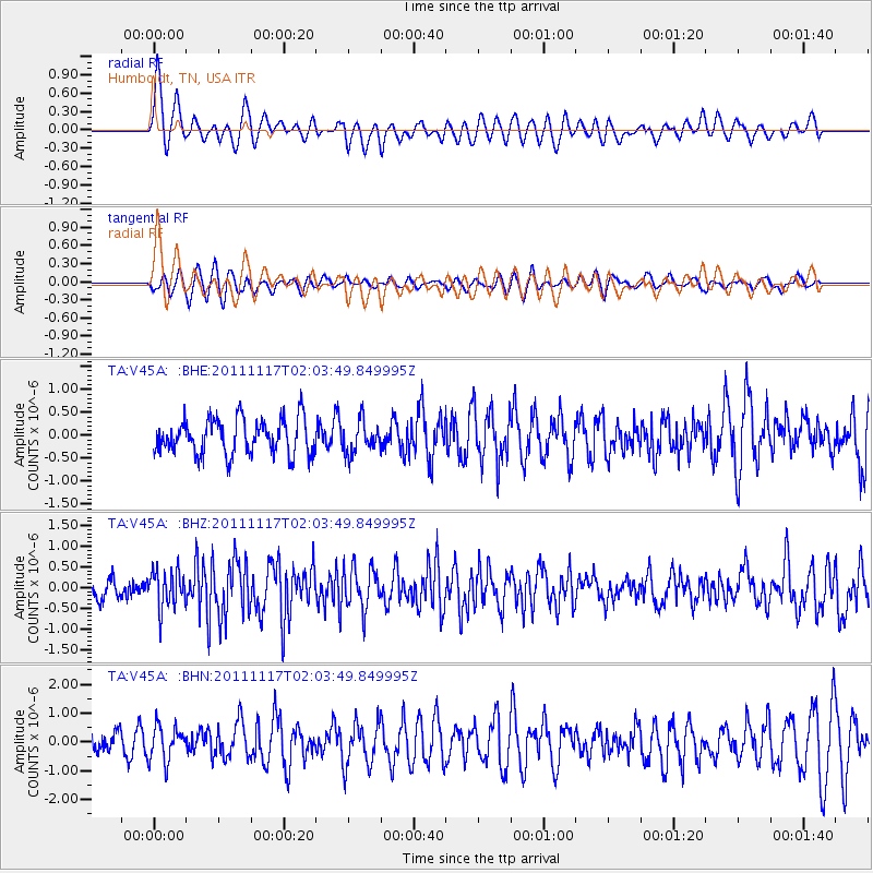
V45A Humboldt, TN, USA - Earthquake Result Viewer
*The percent match for this event was below the threshold and hence no stack was calculated.
| Earthquake location: |
Off Coast Of Ecuador |
| Earthquake latitude/longitude: |
-1.7/-81.5 |
| Earthquake time(UTC): |
2011/11/17 (321) 01:57:05 GMT |
| Earthquake Depth: |
27 km |
| Earthquake Magnitude: |
5.7 MB, 5.6 MS, 6.0 MW, 5.9 MW |
| Earthquake Catalog/Contributor: |
WHDF/NEIC |
|
| Network: |
TA USArray Transportable Network (new EarthScope stations) |
| Station: |
V45A Humboldt, TN, USA |
| Lat/Lon: |
35.74 N/88.96 W |
| Elevation: |
126 m |
|
| Distance: |
37.9 deg |
| Az: |
350.159 deg |
| Baz: |
167.877 deg |
| Ray Param: |
$rayparam |
*The percent match for this event was below the threshold and hence was not used in the summary stack. |
|
| Radial Match: |
75.90707 % |
| Radial Bump: |
400 |
| Transverse Match: |
50.444187 % |
| Transverse Bump: |
400 |
| SOD ConfigId: |
432046 |
| Insert Time: |
2012-02-28 06:42:59.027 +0000 |
| GWidth: |
2.5 |
| Max Bumps: |
400 |
| Tol: |
0.001 |
|
Signal To Noise
| Channel | StoN | STA | LTA |
| TA:V45A: :BHZ:20111117T02:03:49.849995Z | 2.2889245 | 4.5350419E-7 | 1.9812981E-7 |
| TA:V45A: :BHN:20111117T02:03:49.849995Z | 1.3723305 | 6.034805E-7 | 4.3974862E-7 |
| TA:V45A: :BHE:20111117T02:03:49.849995Z | 0.86191267 | 3.2967347E-7 | 3.8249058E-7 |
| Arrivals |
| Ps | |
| PpPs | |
| PsPs/PpSs | |


