You are here: Home > Network List > TA - USArray Transportable Network (new EarthScope stations) Stations List
> Station U42A Revenden, AR, USA > Earthquake Result Viewer
U42A Revenden, AR, USA - Earthquake Result Viewer
| Earthquake location: |
Off Coast Of Ecuador |
| Earthquake latitude/longitude: |
-1.7/-81.5 |
| Earthquake time(UTC): |
2011/11/17 (321) 01:57:05 GMT |
| Earthquake Depth: |
27 km |
| Earthquake Magnitude: |
5.7 MB, 5.6 MS, 6.0 MW, 5.9 MW |
| Earthquake Catalog/Contributor: |
WHDF/NEIC |
|
| Network: |
TA USArray Transportable Network (new EarthScope stations) |
| Station: |
U42A Revenden, AR, USA |
| Lat/Lon: |
36.35 N/91.24 W |
| Elevation: |
119 m |
|
| Distance: |
38.9 deg |
| Az: |
347.506 deg |
| Baz: |
164.463 deg |
| Ray Param: |
0.075238064 |
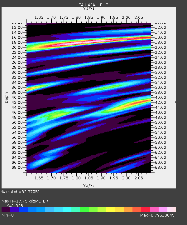
| Estimated Moho Depth: |
17.75 km |
| Estimated Crust Vp/Vs: |
1.83 |
| Assumed Crust Vp: |
6.53 km/s |
| Estimated Crust Vs: |
3.578 km/s |
| Estimated Crust Poisson's Ratio: |
0.29 |
|
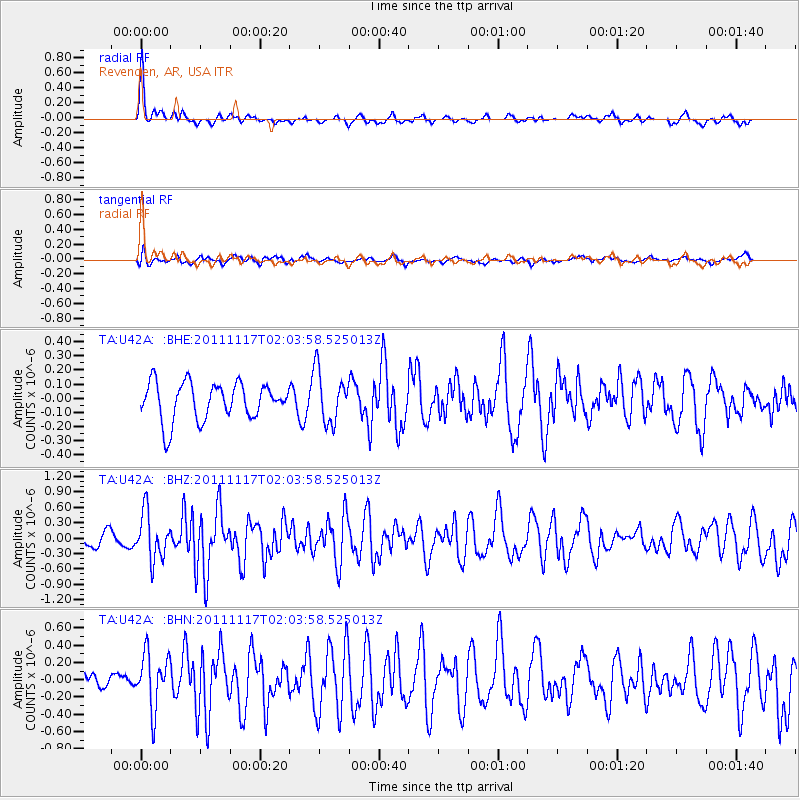
| Radial Match: |
82.37051 % |
| Radial Bump: |
371 |
| Transverse Match: |
47.07082 % |
| Transverse Bump: |
400 |
| SOD ConfigId: |
432046 |
| Insert Time: |
2012-02-28 06:44:42.379 +0000 |
| GWidth: |
2.5 |
| Max Bumps: |
400 |
| Tol: |
0.001 |
|
Signal To Noise
| Channel | StoN | STA | LTA |
| TA:U42A: :BHZ:20111117T02:03:58.525013Z | 2.8890684 | 4.519283E-7 | 1.5642699E-7 |
| TA:U42A: :BHN:20111117T02:03:58.525013Z | 2.6120205 | 3.1605362E-7 | 1.2099967E-7 |
| TA:U42A: :BHE:20111117T02:03:58.525013Z | 1.3931286 | 1.8280045E-7 | 1.3121578E-7 |
| Arrivals |
| Ps | 2.4 SECOND |
| PpPs | 7.1 SECOND |
| PsPs/PpSs | 9.6 SECOND |


