You are here: Home > Network List > TA - USArray Transportable Network (new EarthScope stations) Stations List
> Station O03E Paynes Creek, CA, USA > Earthquake Result Viewer
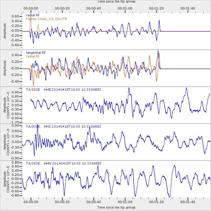
O03E Paynes Creek, CA, USA - Earthquake Result Viewer
*The percent match for this event was below the threshold and hence no stack was calculated.
| Earthquake location: |
Northern Alaska |
| Earthquake latitude/longitude: |
67.7/-162.5 |
| Earthquake time(UTC): |
2014/04/18 (108) 18:56:47 GMT |
| Earthquake Depth: |
17 km |
| Earthquake Magnitude: |
5.7 MW |
| Earthquake Catalog/Contributor: |
ISC/ISC |
|
| Network: |
TA USArray Transportable Network (new EarthScope stations) |
| Station: |
O03E Paynes Creek, CA, USA |
| Lat/Lon: |
40.29 N/121.80 W |
| Elevation: |
967 m |
|
| Distance: |
35.2 deg |
| Az: |
120.194 deg |
| Baz: |
334.458 deg |
| Ray Param: |
$rayparam |
*The percent match for this event was below the threshold and hence was not used in the summary stack. |
|
| Radial Match: |
72.05425 % |
| Radial Bump: |
400 |
| Transverse Match: |
67.33595 % |
| Transverse Bump: |
400 |
| SOD ConfigId: |
3390531 |
| Insert Time: |
2019-04-11 11:39:55.241 +0000 |
| GWidth: |
2.5 |
| Max Bumps: |
400 |
| Tol: |
0.001 |
|
Signal To Noise
| Channel | StoN | STA | LTA |
| TA:O03E: :HHZ:20140418T19:03:10.339988Z | 1.802435 | 3.8263127E-7 | 2.1228576E-7 |
| TA:O03E: :HHN:20140418T19:03:10.339988Z | 0.80350536 | 1.6811782E-7 | 2.092305E-7 |
| TA:O03E: :HHE:20140418T19:03:10.339988Z | 1.3243543 | 2.875479E-7 | 2.1712309E-7 |
| Arrivals |
| Ps | |
| PpPs | |
| PsPs/PpSs | |


