You are here: Home > Network List > TA - USArray Transportable Network (new EarthScope stations) Stations List
> Station Q53A Leroy, WV, USA > Earthquake Result Viewer
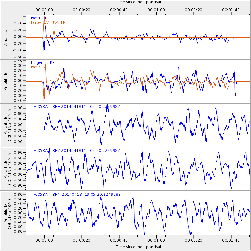
Q53A Leroy, WV, USA - Earthquake Result Viewer
*The percent match for this event was below the threshold and hence no stack was calculated.
| Earthquake location: |
Northern Alaska |
| Earthquake latitude/longitude: |
67.7/-162.5 |
| Earthquake time(UTC): |
2014/04/18 (108) 18:56:47 GMT |
| Earthquake Depth: |
17 km |
| Earthquake Magnitude: |
5.7 MW |
| Earthquake Catalog/Contributor: |
ISC/ISC |
|
| Network: |
TA USArray Transportable Network (new EarthScope stations) |
| Station: |
Q53A Leroy, WV, USA |
| Lat/Lon: |
38.86 N/81.53 W |
| Elevation: |
310 m |
|
| Distance: |
51.4 deg |
| Az: |
80.776 deg |
| Baz: |
331.159 deg |
| Ray Param: |
$rayparam |
*The percent match for this event was below the threshold and hence was not used in the summary stack. |
|
| Radial Match: |
66.53356 % |
| Radial Bump: |
400 |
| Transverse Match: |
52.83215 % |
| Transverse Bump: |
400 |
| SOD ConfigId: |
3390531 |
| Insert Time: |
2019-04-11 11:40:04.527 +0000 |
| GWidth: |
2.5 |
| Max Bumps: |
400 |
| Tol: |
0.001 |
|
Signal To Noise
| Channel | StoN | STA | LTA |
| TA:Q53A: :BHZ:20140418T19:05:20.224998Z | 1.7493639 | 6.1240706E-7 | 3.5007415E-7 |
| TA:Q53A: :BHN:20140418T19:05:20.224998Z | 1.1549381 | 3.8389572E-7 | 3.3239508E-7 |
| TA:Q53A: :BHE:20140418T19:05:20.224998Z | 2.2656991 | 6.3892236E-7 | 2.8199787E-7 |
| Arrivals |
| Ps | |
| PpPs | |
| PsPs/PpSs | |


