You are here: Home > Network List > CI - Caltech Regional Seismic Network Stations List
> Station BEL Belle Mtn, Joshua Tree National Park, CA, USA > Earthquake Result Viewer
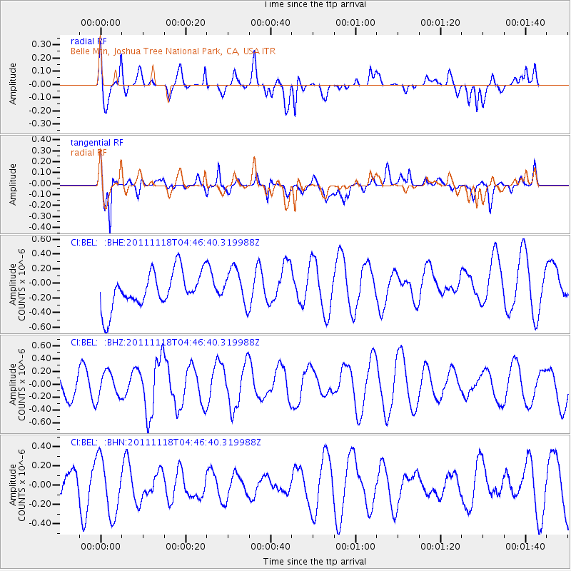
BEL Belle Mtn, Joshua Tree National Park, CA, USA - Earthquake Result Viewer
*The percent match for this event was below the threshold and hence no stack was calculated.
| Earthquake location: |
Off E. Coast Of N. Island, N.Z. |
| Earthquake latitude/longitude: |
-37.4/180.0 |
| Earthquake time(UTC): |
2011/11/18 (322) 04:34:03 GMT |
| Earthquake Depth: |
33 km |
| Earthquake Magnitude: |
5.6 MW, 5.1 MS, 5.4 MB, 5.7 MW |
| Earthquake Catalog/Contributor: |
WHDF/NEIC |
|
| Network: |
CI Caltech Regional Seismic Network |
| Station: |
BEL Belle Mtn, Joshua Tree National Park, CA, USA |
| Lat/Lon: |
34.00 N/116.00 W |
| Elevation: |
1388 m |
|
| Distance: |
92.7 deg |
| Az: |
48.383 deg |
| Baz: |
225.761 deg |
| Ray Param: |
$rayparam |
*The percent match for this event was below the threshold and hence was not used in the summary stack. |
|
| Radial Match: |
69.88168 % |
| Radial Bump: |
400 |
| Transverse Match: |
65.33897 % |
| Transverse Bump: |
400 |
| SOD ConfigId: |
432046 |
| Insert Time: |
2012-02-28 06:58:42.744 +0000 |
| GWidth: |
2.5 |
| Max Bumps: |
400 |
| Tol: |
0.001 |
|
Signal To Noise
| Channel | StoN | STA | LTA |
| CI:BEL: :BHZ:20111118T04:46:40.319988Z | 0.9086757 | 1.9238077E-7 | 2.1171556E-7 |
| CI:BEL: :BHN:20111118T04:46:40.319988Z | 2.138379 | 3.0200823E-7 | 1.412323E-7 |
| CI:BEL: :BHE:20111118T04:46:40.319988Z | 1.0195493 | 2.5044832E-7 | 2.4564613E-7 |
| Arrivals |
| Ps | |
| PpPs | |
| PsPs/PpSs | |


