You are here: Home > Network List > TA - USArray Transportable Network (new EarthScope stations) Stations List
> Station L02D Cave Junction, OR, USA > Earthquake Result Viewer
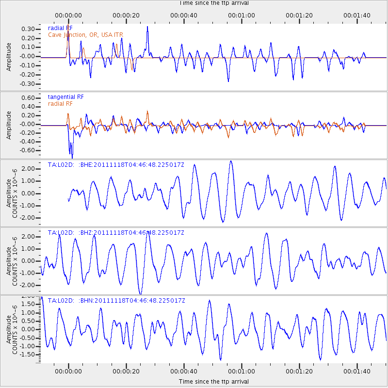
L02D Cave Junction, OR, USA - Earthquake Result Viewer
*The percent match for this event was below the threshold and hence no stack was calculated.
| Earthquake location: |
Off E. Coast Of N. Island, N.Z. |
| Earthquake latitude/longitude: |
-37.4/180.0 |
| Earthquake time(UTC): |
2011/11/18 (322) 04:34:03 GMT |
| Earthquake Depth: |
33 km |
| Earthquake Magnitude: |
5.6 MW, 5.1 MS, 5.4 MB, 5.7 MW |
| Earthquake Catalog/Contributor: |
WHDF/NEIC |
|
| Network: |
TA USArray Transportable Network (new EarthScope stations) |
| Station: |
L02D Cave Junction, OR, USA |
| Lat/Lon: |
42.16 N/123.60 W |
| Elevation: |
458 m |
|
| Distance: |
94.4 deg |
| Az: |
38.405 deg |
| Baz: |
221.695 deg |
| Ray Param: |
$rayparam |
*The percent match for this event was below the threshold and hence was not used in the summary stack. |
|
| Radial Match: |
56.981293 % |
| Radial Bump: |
400 |
| Transverse Match: |
68.02311 % |
| Transverse Bump: |
400 |
| SOD ConfigId: |
432046 |
| Insert Time: |
2012-02-28 06:59:44.285 +0000 |
| GWidth: |
2.5 |
| Max Bumps: |
400 |
| Tol: |
0.001 |
|
Signal To Noise
| Channel | StoN | STA | LTA |
| TA:L02D: :BHZ:20111118T04:46:48.225017Z | 2.1380835 | 1.3115317E-6 | 6.1341467E-7 |
| TA:L02D: :BHN:20111118T04:46:48.225017Z | 0.5303381 | 5.476868E-7 | 1.0327125E-6 |
| TA:L02D: :BHE:20111118T04:46:48.225017Z | 0.98481 | 6.6258644E-7 | 6.728064E-7 |
| Arrivals |
| Ps | |
| PpPs | |
| PsPs/PpSs | |


