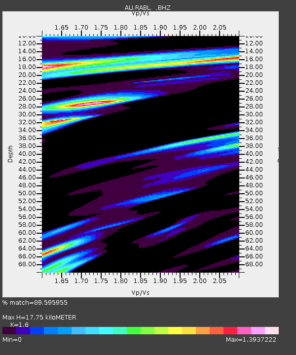
RABL Rabaul, Papau New Guinea - Earthquake Result Viewer

Earthquake location: Off E. Coast Of N. Island, N.Z.
Earthquake latitude/longitude: -37.8/179.4
Earthquake time(UTC): 2011/11/18 (322) 07:51:24 GMT
Earthquake Depth: 12 km
Earthquake Magnitude: 5.8 MB, 5.6 MS, 5.8 MW, 5.7 MW
Earthquake Catalog/Contributor: WHDF/NEIC
Network: AU Australian Seismological Centre
Station: RABL Rabaul, Papau New Guinea
Lat/Lon: 4.19 S/152.16 E
Elevation: 277 m
Distance: 41.7 deg
Az: 316.644 deg
Baz: 146.96 deg
Ray Param: 0.07361913
Estimated Moho Depth: 17.75 km
Estimated Crust Vp/Vs: 1.60
Assumed Crust Vp: 6.183 km/s
Estimated Crust Vs: 3.864 km/s
Estimated Crust Poisson's Ratio: 0.18
Radial Match: 89.595955 %
Radial Bump: 400
Transverse Match: 86.683914 %
Transverse Bump: 400
SOD ConfigId: 432046
Insert Time: 2012-02-28 07:08:01.324 +0000
GWidth: 2.5
Max Bumps: 400
Tol: 0.001

Signal To Noise

ChannelStoNSTALTA
AU:RABL: :BHZ:20111118T07:58:42.344998Z9.7287422.2761253E-62.3395887E-7
AU:RABL: :BHN:20111118T07:58:42.344998Z1.44598291.0129141E-67.005022E-7
AU:RABL: :BHE:20111118T07:58:42.344998Z2.07803151.3440824E-66.4680563E-7
Arrivals
Ps1.8 SECOND
PpPs7.0 SECOND
PsPs/PpSs8.8 SECOND