You are here: Home > Network List > CI - Caltech Regional Seismic Network Stations List
> Station SWS Sam W. Stewart, Westmorland, CA, USA > Earthquake Result Viewer
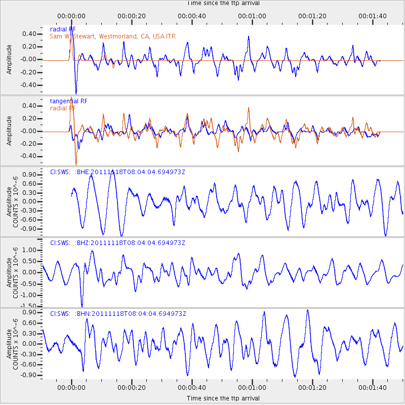
SWS Sam W. Stewart, Westmorland, CA, USA - Earthquake Result Viewer
*The percent match for this event was below the threshold and hence no stack was calculated.
| Earthquake location: |
Off E. Coast Of N. Island, N.Z. |
| Earthquake latitude/longitude: |
-37.8/179.4 |
| Earthquake time(UTC): |
2011/11/18 (322) 07:51:24 GMT |
| Earthquake Depth: |
12 km |
| Earthquake Magnitude: |
5.8 MB, 5.6 MS, 5.8 MW, 5.7 MW |
| Earthquake Catalog/Contributor: |
WHDF/NEIC |
|
| Network: |
CI Caltech Regional Seismic Network |
| Station: |
SWS Sam W. Stewart, Westmorland, CA, USA |
| Lat/Lon: |
32.94 N/115.80 W |
| Elevation: |
140 m |
|
| Distance: |
92.7 deg |
| Az: |
49.606 deg |
| Baz: |
225.84 deg |
| Ray Param: |
$rayparam |
*The percent match for this event was below the threshold and hence was not used in the summary stack. |
|
| Radial Match: |
63.320644 % |
| Radial Bump: |
383 |
| Transverse Match: |
50.435318 % |
| Transverse Bump: |
400 |
| SOD ConfigId: |
432046 |
| Insert Time: |
2012-02-28 07:09:55.240 +0000 |
| GWidth: |
2.5 |
| Max Bumps: |
400 |
| Tol: |
0.001 |
|
Signal To Noise
| Channel | StoN | STA | LTA |
| CI:SWS: :BHZ:20111118T08:04:04.694973Z | 2.1104932 | 5.5792003E-7 | 2.643553E-7 |
| CI:SWS: :BHN:20111118T08:04:04.694973Z | 1.0949626 | 2.8476222E-7 | 2.600657E-7 |
| CI:SWS: :BHE:20111118T08:04:04.694973Z | 0.4721505 | 2.7707185E-7 | 5.8682946E-7 |
| Arrivals |
| Ps | |
| PpPs | |
| PsPs/PpSs | |


