You are here: Home > Network List > US - United States National Seismic Network Stations List
> Station DGMT Dagmar, Montana, USA > Earthquake Result Viewer
DGMT Dagmar, Montana, USA - Earthquake Result Viewer
*The percent match for this event was below the threshold and hence no stack was calculated.
| Earthquake location: |
Northern Alaska |
| Earthquake latitude/longitude: |
67.7/-162.5 |
| Earthquake time(UTC): |
2014/04/18 (108) 18:56:47 GMT |
| Earthquake Depth: |
17 km |
| Earthquake Magnitude: |
5.7 MW |
| Earthquake Catalog/Contributor: |
ISC/ISC |
|
| Network: |
US United States National Seismic Network |
| Station: |
DGMT Dagmar, Montana, USA |
| Lat/Lon: |
48.47 N/104.20 W |
| Elevation: |
0.0 m |
|
| Distance: |
34.6 deg |
| Az: |
93.879 deg |
| Baz: |
325.109 deg |
| Ray Param: |
$rayparam |
*The percent match for this event was below the threshold and hence was not used in the summary stack. |
|
| Radial Match: |
48.60759 % |
| Radial Bump: |
400 |
| Transverse Match: |
46.20383 % |
| Transverse Bump: |
400 |
| SOD ConfigId: |
3390531 |
| Insert Time: |
2019-04-11 11:41:03.524 +0000 |
| GWidth: |
2.5 |
| Max Bumps: |
400 |
| Tol: |
0.001 |
|
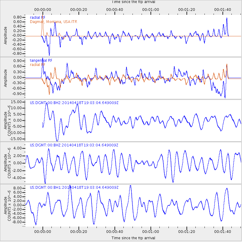
Signal To Noise
| Channel | StoN | STA | LTA |
| US:DGMT:00:BHZ:20140418T19:03:04.649009Z | 1.4537058 | 2.6678824E-6 | 1.8352287E-6 |
| US:DGMT:00:BH1:20140418T19:03:04.649009Z | 0.64739 | 2.702098E-6 | 4.1738335E-6 |
| US:DGMT:00:BH2:20140418T19:03:04.649009Z | 0.55013096 | 4.2858696E-6 | 7.790635E-6 |
| Arrivals |
| Ps | |
| PpPs | |
| PsPs/PpSs | |


