You are here: Home > Network List > TA - USArray Transportable Network (new EarthScope stations) Stations List
> Station M04C Macdoel, CA, USA > Earthquake Result Viewer
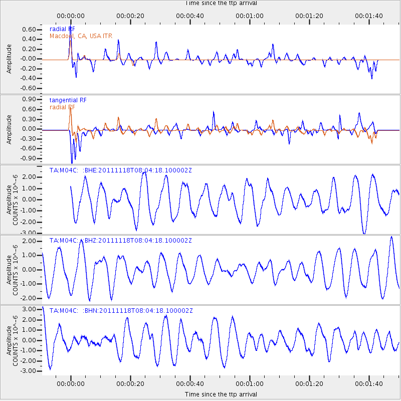
M04C Macdoel, CA, USA - Earthquake Result Viewer
*The percent match for this event was below the threshold and hence no stack was calculated.
| Earthquake location: |
Off E. Coast Of N. Island, N.Z. |
| Earthquake latitude/longitude: |
-37.8/179.4 |
| Earthquake time(UTC): |
2011/11/18 (322) 07:51:24 GMT |
| Earthquake Depth: |
12 km |
| Earthquake Magnitude: |
5.8 MB, 5.6 MS, 5.8 MW, 5.7 MW |
| Earthquake Catalog/Contributor: |
WHDF/NEIC |
|
| Network: |
TA USArray Transportable Network (new EarthScope stations) |
| Station: |
M04C Macdoel, CA, USA |
| Lat/Lon: |
41.78 N/121.84 W |
| Elevation: |
1391 m |
|
| Distance: |
95.6 deg |
| Az: |
39.972 deg |
| Baz: |
222.872 deg |
| Ray Param: |
$rayparam |
*The percent match for this event was below the threshold and hence was not used in the summary stack. |
|
| Radial Match: |
49.948837 % |
| Radial Bump: |
400 |
| Transverse Match: |
82.0446 % |
| Transverse Bump: |
338 |
| SOD ConfigId: |
432046 |
| Insert Time: |
2012-02-28 07:12:44.562 +0000 |
| GWidth: |
2.5 |
| Max Bumps: |
400 |
| Tol: |
0.001 |
|
Signal To Noise
| Channel | StoN | STA | LTA |
| TA:M04C: :BHZ:20111118T08:04:18.100002Z | 1.6067578 | 1.3837106E-6 | 8.6118183E-7 |
| TA:M04C: :BHN:20111118T08:04:18.100002Z | 0.23027302 | 4.6839426E-7 | 2.0340822E-6 |
| TA:M04C: :BHE:20111118T08:04:18.100002Z | 1.1298388 | 1.3897352E-6 | 1.2300296E-6 |
| Arrivals |
| Ps | |
| PpPs | |
| PsPs/PpSs | |


