You are here: Home > Network List > TA - USArray Transportable Network (new EarthScope stations) Stations List
> Station J04D Umpqua National Forest, Toketee, OR, USA > Earthquake Result Viewer
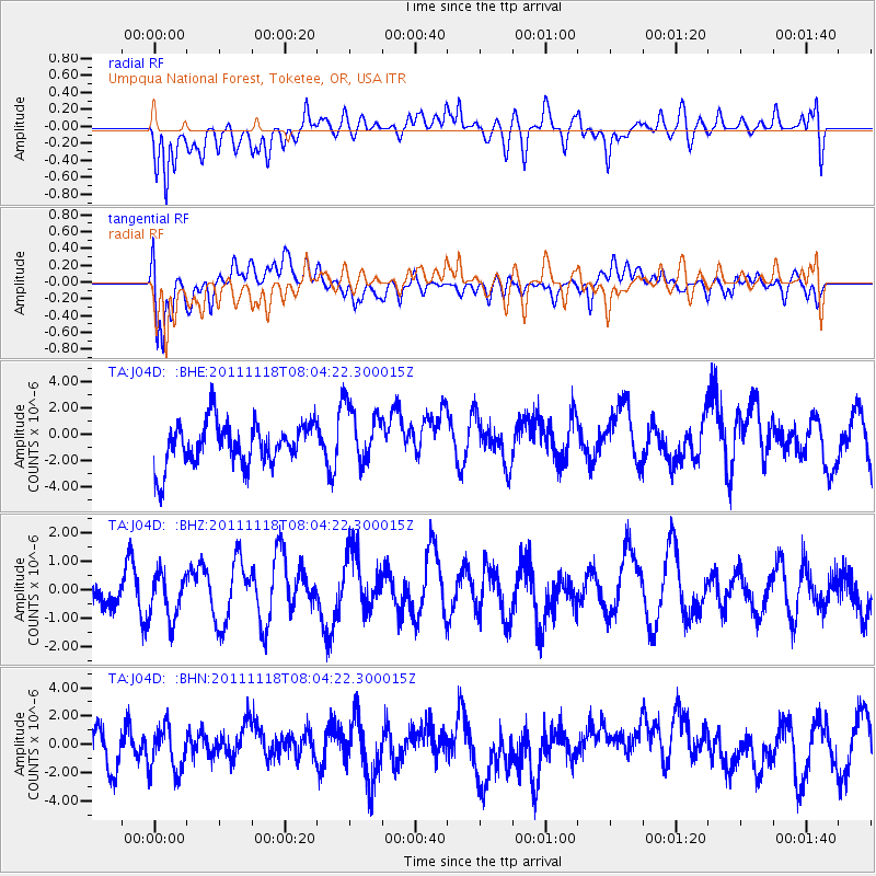
J04D Umpqua National Forest, Toketee, OR, USA - Earthquake Result Viewer
*The percent match for this event was below the threshold and hence no stack was calculated.
| Earthquake location: |
Off E. Coast Of N. Island, N.Z. |
| Earthquake latitude/longitude: |
-37.8/179.4 |
| Earthquake time(UTC): |
2011/11/18 (322) 07:51:24 GMT |
| Earthquake Depth: |
12 km |
| Earthquake Magnitude: |
5.8 MB, 5.6 MS, 5.8 MW, 5.7 MW |
| Earthquake Catalog/Contributor: |
WHDF/NEIC |
|
| Network: |
TA USArray Transportable Network (new EarthScope stations) |
| Station: |
J04D Umpqua National Forest, Toketee, OR, USA |
| Lat/Lon: |
43.24 N/122.11 W |
| Elevation: |
1948 m |
|
| Distance: |
96.5 deg |
| Az: |
38.829 deg |
| Baz: |
222.812 deg |
| Ray Param: |
$rayparam |
*The percent match for this event was below the threshold and hence was not used in the summary stack. |
|
| Radial Match: |
50.01131 % |
| Radial Bump: |
400 |
| Transverse Match: |
63.644928 % |
| Transverse Bump: |
400 |
| SOD ConfigId: |
432046 |
| Insert Time: |
2012-02-28 07:12:58.847 +0000 |
| GWidth: |
2.5 |
| Max Bumps: |
400 |
| Tol: |
0.001 |
|
Signal To Noise
| Channel | StoN | STA | LTA |
| TA:J04D: :BHZ:20111118T08:04:22.300015Z | 1.086322 | 8.1817115E-7 | 7.5315717E-7 |
| TA:J04D: :BHN:20111118T08:04:22.300015Z | 1.0859479 | 1.6683069E-6 | 1.5362681E-6 |
| TA:J04D: :BHE:20111118T08:04:22.300015Z | 1.3813894 | 2.2246331E-6 | 1.6104317E-6 |
| Arrivals |
| Ps | |
| PpPs | |
| PsPs/PpSs | |


