You are here: Home > Network List > TA - USArray Transportable Network (new EarthScope stations) Stations List
> Station O03D Paynes Creek, CA, USA > Earthquake Result Viewer
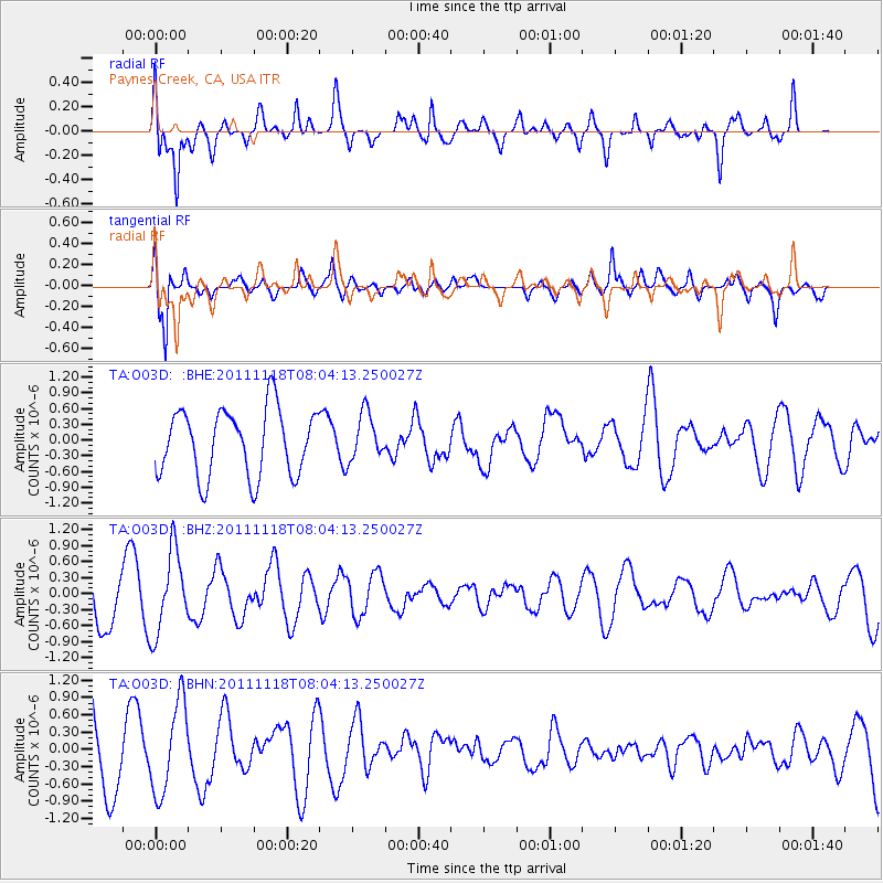
O03D Paynes Creek, CA, USA - Earthquake Result Viewer
*The percent match for this event was below the threshold and hence no stack was calculated.
| Earthquake location: |
Off E. Coast Of N. Island, N.Z. |
| Earthquake latitude/longitude: |
-37.8/179.4 |
| Earthquake time(UTC): |
2011/11/18 (322) 07:51:24 GMT |
| Earthquake Depth: |
12 km |
| Earthquake Magnitude: |
5.8 MB, 5.6 MS, 5.8 MW, 5.7 MW |
| Earthquake Catalog/Contributor: |
WHDF/NEIC |
|
| Network: |
TA USArray Transportable Network (new EarthScope stations) |
| Station: |
O03D Paynes Creek, CA, USA |
| Lat/Lon: |
40.29 N/121.80 W |
| Elevation: |
968 m |
|
| Distance: |
94.5 deg |
| Az: |
41.008 deg |
| Baz: |
222.805 deg |
| Ray Param: |
$rayparam |
*The percent match for this event was below the threshold and hence was not used in the summary stack. |
|
| Radial Match: |
69.9515 % |
| Radial Bump: |
400 |
| Transverse Match: |
78.59473 % |
| Transverse Bump: |
400 |
| SOD ConfigId: |
432046 |
| Insert Time: |
2012-02-28 07:13:06.010 +0000 |
| GWidth: |
2.5 |
| Max Bumps: |
400 |
| Tol: |
0.001 |
|
Signal To Noise
| Channel | StoN | STA | LTA |
| TA:O03D: :BHZ:20111118T08:04:13.250027Z | 1.425209 | 7.6594046E-7 | 5.3742326E-7 |
| TA:O03D: :BHN:20111118T08:04:13.250027Z | 1.1772578 | 7.8609776E-7 | 6.677363E-7 |
| TA:O03D: :BHE:20111118T08:04:13.250027Z | 0.70239484 | 4.4675568E-7 | 6.3604637E-7 |
| Arrivals |
| Ps | |
| PpPs | |
| PsPs/PpSs | |


