You are here: Home > Network List > MN - MEDNET Project Stations List
> Station CEL Celeste, Italy > Earthquake Result Viewer
CEL Celeste, Italy - Earthquake Result Viewer
| Earthquake location: |
Myanmar |
| Earthquake latitude/longitude: |
25.0/95.2 |
| Earthquake time(UTC): |
2011/11/21 (325) 03:15:42 GMT |
| Earthquake Depth: |
114 km |
| Earthquake Magnitude: |
5.9 MB, 5.7 MW, 5.7 MW |
| Earthquake Catalog/Contributor: |
WHDF/NEIC |
|
| Network: |
MN MEDNET Project |
| Station: |
CEL Celeste, Italy |
| Lat/Lon: |
38.26 N/15.89 E |
| Elevation: |
702 m |
|
| Distance: |
67.0 deg |
| Az: |
302.805 deg |
| Baz: |
75.736 deg |
| Ray Param: |
0.05694856 |
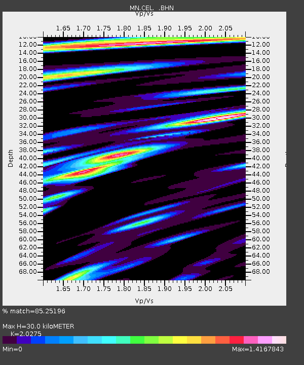
| Estimated Moho Depth: |
30.0 km |
| Estimated Crust Vp/Vs: |
2.03 |
| Assumed Crust Vp: |
5.782 km/s |
| Estimated Crust Vs: |
2.852 km/s |
| Estimated Crust Poisson's Ratio: |
0.34 |
|
| Radial Match: |
85.25196 % |
| Radial Bump: |
400 |
| Transverse Match: |
87.29632 % |
| Transverse Bump: |
400 |
| SOD ConfigId: |
432046 |
| Insert Time: |
2012-03-03 05:18:41.705 +0000 |
| GWidth: |
2.5 |
| Max Bumps: |
400 |
| Tol: |
0.001 |
|

Signal To Noise
| Channel | StoN | STA | LTA |
| MN:CEL: :BHZ:20111121T03:25:52.115989Z | 13.510635 | 1.1725137E-6 | 8.6784496E-8 |
| MN:CEL: :BHN:20111121T03:25:52.115989Z | 4.705787 | 3.2403784E-7 | 6.8859435E-8 |
| MN:CEL: :BHE:20111121T03:25:52.115989Z | 4.2630453 | 3.7669042E-7 | 8.836181E-8 |
| Arrivals |
| Ps | 5.5 SECOND |
| PpPs | 15 SECOND |
| PsPs/PpSs | 21 SECOND |


