You are here: Home > Network List > C - Chilean National Seismic Network Stations List
> Station GO09 Cerro Castillo, Chile > Earthquake Result Viewer
GO09 Cerro Castillo, Chile - Earthquake Result Viewer
| Earthquake location: |
Central Bolivia |
| Earthquake latitude/longitude: |
-15.4/-65.1 |
| Earthquake time(UTC): |
2011/11/22 (326) 18:48:16 GMT |
| Earthquake Depth: |
550 km |
| Earthquake Magnitude: |
6.2 MB, 6.6 MW, 6.6 MW |
| Earthquake Catalog/Contributor: |
WHDF/NEIC |
|
| Network: |
C Chilean National Seismic Network |
| Station: |
GO09 Cerro Castillo, Chile |
| Lat/Lon: |
51.27 S/72.34 W |
| Elevation: |
372 m |
|
| Distance: |
36.3 deg |
| Az: |
187.696 deg |
| Baz: |
11.868 deg |
| Ray Param: |
0.07405088 |
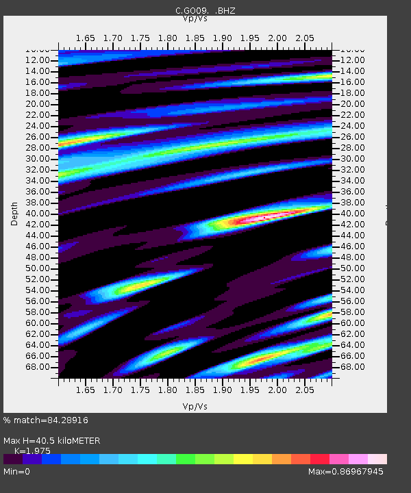
| Estimated Moho Depth: |
40.5 km |
| Estimated Crust Vp/Vs: |
1.98 |
| Assumed Crust Vp: |
6.438 km/s |
| Estimated Crust Vs: |
3.26 km/s |
| Estimated Crust Poisson's Ratio: |
0.33 |
|
| Radial Match: |
84.28916 % |
| Radial Bump: |
400 |
| Transverse Match: |
79.28679 % |
| Transverse Bump: |
400 |
| SOD ConfigId: |
432046 |
| Insert Time: |
2012-03-03 05:27:13.261 +0000 |
| GWidth: |
2.5 |
| Max Bumps: |
400 |
| Tol: |
0.001 |
|

Signal To Noise
| Channel | StoN | STA | LTA |
| C:GO09: :BHZ:20111122T18:54:03.150006Z | 15.07356 | 1.4909753E-5 | 9.891329E-7 |
| C:GO09: :BHN:20111122T18:54:03.150006Z | 8.302761 | 6.2770287E-6 | 7.56017E-7 |
| C:GO09: :BHE:20111122T18:54:03.150006Z | 2.2207506 | 1.7192939E-6 | 7.741949E-7 |
| Arrivals |
| Ps | 6.5 SECOND |
| PpPs | 18 SECOND |
| PsPs/PpSs | 24 SECOND |


