You are here: Home > Network List > TA - USArray Transportable Network (new EarthScope stations) Stations List
> Station J05D Fort Rock, OR, USA > Earthquake Result Viewer
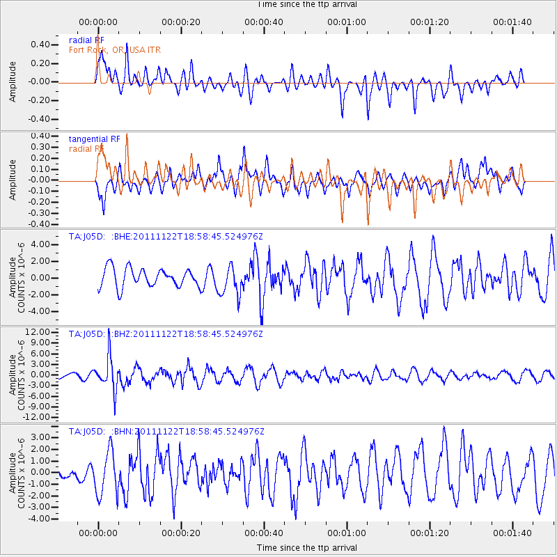
J05D Fort Rock, OR, USA - Earthquake Result Viewer
*The percent match for this event was below the threshold and hence no stack was calculated.
| Earthquake location: |
Central Bolivia |
| Earthquake latitude/longitude: |
-15.4/-65.1 |
| Earthquake time(UTC): |
2011/11/22 (326) 18:48:16 GMT |
| Earthquake Depth: |
550 km |
| Earthquake Magnitude: |
6.2 MB, 6.6 MW, 6.6 MW |
| Earthquake Catalog/Contributor: |
WHDF/NEIC |
|
| Network: |
TA USArray Transportable Network (new EarthScope stations) |
| Station: |
J05D Fort Rock, OR, USA |
| Lat/Lon: |
43.28 N/121.23 W |
| Elevation: |
1541 m |
|
| Distance: |
77.7 deg |
| Az: |
321.639 deg |
| Baz: |
124.927 deg |
| Ray Param: |
$rayparam |
*The percent match for this event was below the threshold and hence was not used in the summary stack. |
|
| Radial Match: |
74.72432 % |
| Radial Bump: |
390 |
| Transverse Match: |
60.945118 % |
| Transverse Bump: |
400 |
| SOD ConfigId: |
432046 |
| Insert Time: |
2012-03-03 05:42:32.765 +0000 |
| GWidth: |
2.5 |
| Max Bumps: |
400 |
| Tol: |
0.001 |
|
Signal To Noise
| Channel | StoN | STA | LTA |
| TA:J05D: :BHZ:20111122T18:58:45.524976Z | 4.0176206 | 4.753875E-6 | 1.1832564E-6 |
| TA:J05D: :BHN:20111122T18:58:45.524976Z | 3.870154 | 1.9465729E-6 | 5.029704E-7 |
| TA:J05D: :BHE:20111122T18:58:45.524976Z | 1.6103631 | 1.7968682E-6 | 1.1158156E-6 |
| Arrivals |
| Ps | |
| PpPs | |
| PsPs/PpSs | |


