You are here: Home > Network List > TA - USArray Transportable Network (new EarthScope stations) Stations List
> Station G05D Wamic, OR, USA > Earthquake Result Viewer
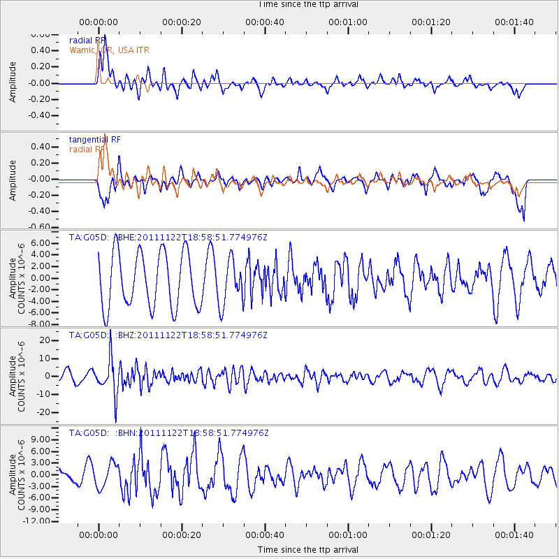
G05D Wamic, OR, USA - Earthquake Result Viewer
*The percent match for this event was below the threshold and hence no stack was calculated.
| Earthquake location: |
Central Bolivia |
| Earthquake latitude/longitude: |
-15.4/-65.1 |
| Earthquake time(UTC): |
2011/11/22 (326) 18:48:16 GMT |
| Earthquake Depth: |
550 km |
| Earthquake Magnitude: |
6.2 MB, 6.6 MW, 6.6 MW |
| Earthquake Catalog/Contributor: |
WHDF/NEIC |
|
| Network: |
TA USArray Transportable Network (new EarthScope stations) |
| Station: |
G05D Wamic, OR, USA |
| Lat/Lon: |
45.24 N/121.32 W |
| Elevation: |
592 m |
|
| Distance: |
78.9 deg |
| Az: |
323.24 deg |
| Baz: |
125.194 deg |
| Ray Param: |
$rayparam |
*The percent match for this event was below the threshold and hence was not used in the summary stack. |
|
| Radial Match: |
66.15881 % |
| Radial Bump: |
400 |
| Transverse Match: |
43.58102 % |
| Transverse Bump: |
400 |
| SOD ConfigId: |
432046 |
| Insert Time: |
2012-03-03 05:42:45.187 +0000 |
| GWidth: |
2.5 |
| Max Bumps: |
400 |
| Tol: |
0.001 |
|
Signal To Noise
| Channel | StoN | STA | LTA |
| TA:G05D: :BHZ:20111122T18:58:51.774976Z | 3.7649465 | 1.0007037E-5 | 2.6579494E-6 |
| TA:G05D: :BHN:20111122T18:58:51.774976Z | 1.602553 | 3.1173583E-6 | 1.9452452E-6 |
| TA:G05D: :BHE:20111122T18:58:51.774976Z | 0.8284791 | 3.8991975E-6 | 4.7064523E-6 |
| Arrivals |
| Ps | |
| PpPs | |
| PsPs/PpSs | |


