You are here: Home > Network List > TA - USArray Transportable Network (new EarthScope stations) Stations List
> Station K32A Verdigre, NE, USA > Earthquake Result Viewer
K32A Verdigre, NE, USA - Earthquake Result Viewer
| Earthquake location: |
Central Bolivia |
| Earthquake latitude/longitude: |
-15.4/-65.1 |
| Earthquake time(UTC): |
2011/11/22 (326) 18:48:16 GMT |
| Earthquake Depth: |
550 km |
| Earthquake Magnitude: |
6.2 MB, 6.6 MW, 6.6 MW |
| Earthquake Catalog/Contributor: |
WHDF/NEIC |
|
| Network: |
TA USArray Transportable Network (new EarthScope stations) |
| Station: |
K32A Verdigre, NE, USA |
| Lat/Lon: |
42.66 N/97.97 W |
| Elevation: |
512 m |
|
| Distance: |
65.2 deg |
| Az: |
333.816 deg |
| Baz: |
144.754 deg |
| Ray Param: |
0.056441586 |
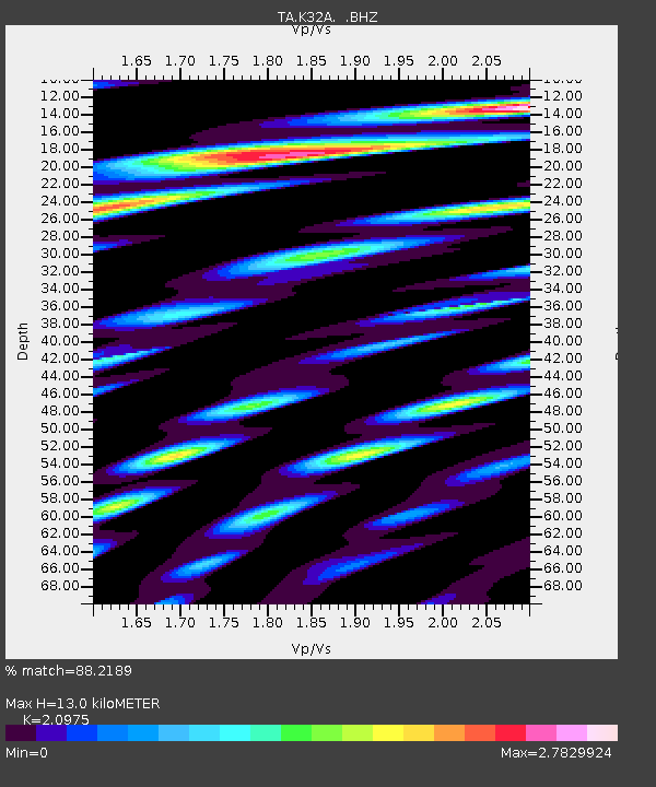
| Estimated Moho Depth: |
13.0 km |
| Estimated Crust Vp/Vs: |
2.10 |
| Assumed Crust Vp: |
6.498 km/s |
| Estimated Crust Vs: |
3.098 km/s |
| Estimated Crust Poisson's Ratio: |
0.35 |
|
| Radial Match: |
88.2189 % |
| Radial Bump: |
400 |
| Transverse Match: |
70.29369 % |
| Transverse Bump: |
400 |
| SOD ConfigId: |
432046 |
| Insert Time: |
2012-03-03 05:49:27.865 +0000 |
| GWidth: |
2.5 |
| Max Bumps: |
400 |
| Tol: |
0.001 |
|

Signal To Noise
| Channel | StoN | STA | LTA |
| TA:K32A: :BHZ:20111122T18:57:32.524976Z | 32.740257 | 4.467003E-6 | 1.3643762E-7 |
| TA:K32A: :BHN:20111122T18:57:32.524976Z | 13.392275 | 3.233869E-6 | 2.4147272E-7 |
| TA:K32A: :BHE:20111122T18:57:32.524976Z | 10.186506 | 2.680911E-6 | 2.6318256E-7 |
| Arrivals |
| Ps | 2.3 SECOND |
| PpPs | 6.0 SECOND |
| PsPs/PpSs | 8.3 SECOND |


