You are here: Home > Network List > TA - USArray Transportable Network (new EarthScope stations) Stations List
> Station J01D Myrtle Point, OR, USA > Earthquake Result Viewer
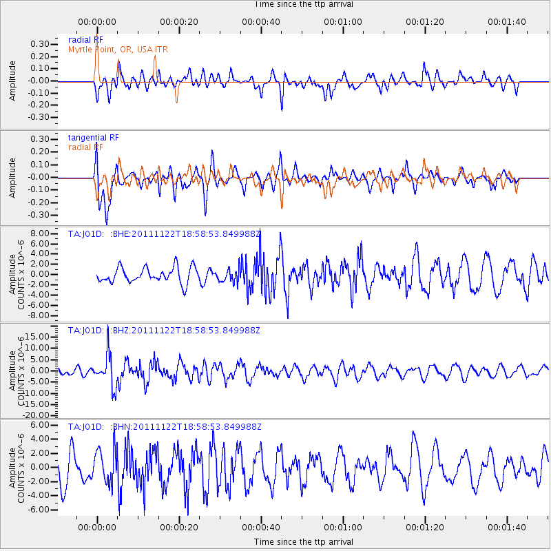
J01D Myrtle Point, OR, USA - Earthquake Result Viewer
*The percent match for this event was below the threshold and hence no stack was calculated.
| Earthquake location: |
Central Bolivia |
| Earthquake latitude/longitude: |
-15.4/-65.1 |
| Earthquake time(UTC): |
2011/11/22 (326) 18:48:16 GMT |
| Earthquake Depth: |
550 km |
| Earthquake Magnitude: |
6.2 MB, 6.6 MW, 6.6 MW |
| Earthquake Catalog/Contributor: |
WHDF/NEIC |
|
| Network: |
TA USArray Transportable Network (new EarthScope stations) |
| Station: |
J01D Myrtle Point, OR, USA |
| Lat/Lon: |
43.16 N/123.93 W |
| Elevation: |
131 m |
|
| Distance: |
79.3 deg |
| Az: |
320.413 deg |
| Baz: |
122.842 deg |
| Ray Param: |
$rayparam |
*The percent match for this event was below the threshold and hence was not used in the summary stack. |
|
| Radial Match: |
54.448532 % |
| Radial Bump: |
400 |
| Transverse Match: |
53.032806 % |
| Transverse Bump: |
400 |
| SOD ConfigId: |
432046 |
| Insert Time: |
2012-03-03 05:50:48.846 +0000 |
| GWidth: |
2.5 |
| Max Bumps: |
400 |
| Tol: |
0.001 |
|
Signal To Noise
| Channel | StoN | STA | LTA |
| TA:J01D: :BHZ:20111122T18:58:53.849988Z | 5.833691 | 7.2549483E-6 | 1.2436292E-6 |
| TA:J01D: :BHN:20111122T18:58:53.849988Z | 1.205471 | 2.4188114E-6 | 2.006528E-6 |
| TA:J01D: :BHE:20111122T18:58:53.849988Z | 0.862087 | 1.2758386E-6 | 1.4799418E-6 |
| Arrivals |
| Ps | |
| PpPs | |
| PsPs/PpSs | |


