You are here: Home > Network List > TA - USArray Transportable Network (new EarthScope stations) Stations List
> Station C31A Landman Farms, Northwood, ND, USA > Earthquake Result Viewer
C31A Landman Farms, Northwood, ND, USA - Earthquake Result Viewer
| Earthquake location: |
Central Bolivia |
| Earthquake latitude/longitude: |
-15.4/-65.1 |
| Earthquake time(UTC): |
2011/11/22 (326) 18:48:16 GMT |
| Earthquake Depth: |
550 km |
| Earthquake Magnitude: |
6.2 MB, 6.6 MW, 6.6 MW |
| Earthquake Catalog/Contributor: |
WHDF/NEIC |
|
| Network: |
TA USArray Transportable Network (new EarthScope stations) |
| Station: |
C31A Landman Farms, Northwood, ND, USA |
| Lat/Lon: |
47.79 N/97.73 W |
| Elevation: |
384 m |
|
| Distance: |
69.3 deg |
| Az: |
337.121 deg |
| Baz: |
146.203 deg |
| Ray Param: |
0.05383745 |
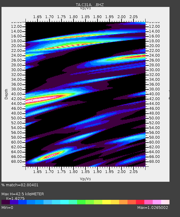
| Estimated Moho Depth: |
42.5 km |
| Estimated Crust Vp/Vs: |
1.63 |
| Assumed Crust Vp: |
6.498 km/s |
| Estimated Crust Vs: |
3.992 km/s |
| Estimated Crust Poisson's Ratio: |
0.20 |
|
| Radial Match: |
82.80401 % |
| Radial Bump: |
400 |
| Transverse Match: |
55.530888 % |
| Transverse Bump: |
400 |
| SOD ConfigId: |
432046 |
| Insert Time: |
2012-03-03 05:52:15.816 +0000 |
| GWidth: |
2.5 |
| Max Bumps: |
400 |
| Tol: |
0.001 |
|

Signal To Noise
| Channel | StoN | STA | LTA |
| TA:C31A: :BHZ:20111122T18:57:57.800Z | 14.551365 | 3.187749E-6 | 2.1906872E-7 |
| TA:C31A: :BHN:20111122T18:57:57.800Z | 5.4574275 | 1.8710963E-6 | 3.4285316E-7 |
| TA:C31A: :BHE:20111122T18:57:57.800Z | 5.166326 | 1.3435804E-6 | 2.6006498E-7 |
| Arrivals |
| Ps | 4.3 SECOND |
| PpPs | 17 SECOND |
| PsPs/PpSs | 21 SECOND |


